|
HURRICANE RELIEF:
1-800-HELP-NOW
AMERICAN
RED CROSS
Click here to view the Forecast/Discussion archive for this storm
Tropical Depression Fay Discussion Number  35
NWS National Hurricane Center Miami FL       AL062026
500 PM AST Mon Sep 28 2026

Fay has continued to produce bursts of deep convection this
afternoon, primarily sheared to the south of the low-level center.
The overall satellite presentation has improved slightly since
earlier today, featuring cold cloud tops near -70C. Objective
UW-CIMSS satellite intensity estimates have been running slightly
higher than the scatterometer-derived surface wind data from earlier
today. However, the subjective Dvorak intensity estimate from TAFB
has held steady at T2.0/30 kt. Accordingly, the initial intensity is
maintained at 30 kt for this advisory.

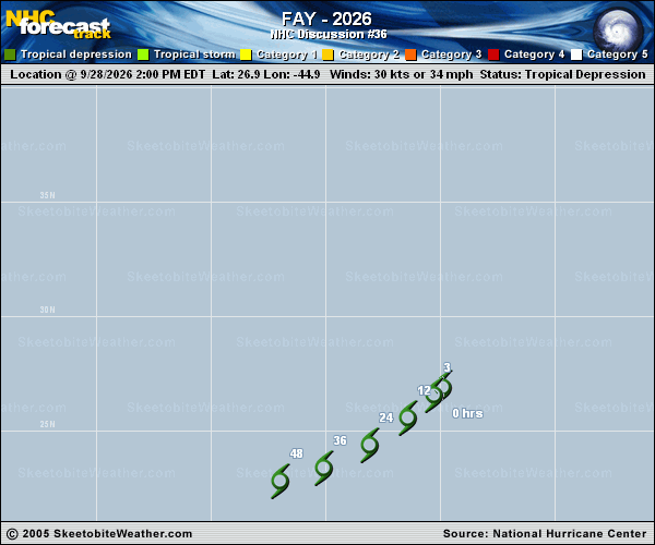
The depression is moving southwestward with an estimated initial
motion of 220/8 kt. A general southwest to west-southwest motion is
anticipated over the next couple of days as Fay is steered by the
flow along the southern periphery of a mid-level ridge situated over
the central Atlantic. The latest NHC track forecast is essentially
an update of the previous advisory and lies very close to the HCCA
corrected-consensus aid.

Fay continues to defy model guidance by maintaining deep convection
near its low-level center. Given that vertical wind shear remains
low-to-moderate and sea surface temperatures are near 29C, it is
entirely possible that Fay could briefly regain tropical storm
strength tonight. Global models persist in showing that the system
will struggle to sustain deep convection in a day or so as it
encounters a more stable air mass and upper-level convergence.
Nevertheless, Fay has proven to be a resilient, small system. The
latest NHC intensity forecast holds Fay steady through Tuesday
followed by gradual weakening, with the system forecast to become a
post-tropical cyclone in a day or so, and degenerate into a remnant
trough in a couple of days.


FORECAST POSITIONS AND MAX WINDS

INIT  28/2100Z 26.6N  45.3W   30 KT  35 MPH
12H  29/0600Z 25.6N  46.4W   30 KT  35 MPH
24H  29/1800Z 24.4N  48.1W   30 KT  35 MPH
36H  30/0600Z 23.4N  50.1W   30 KT  35 MPH...POST-TROP/REMNT LOW
48H  30/1800Z 22.8N  52.0W   25 KT  30 MPH...POST-TROP/REMNT LOW
60H  01/0600Z...DISSIPATED

$$
Forecaster Kelly
 | 
