Official Discussion issued by the National Hurricane Center
Tammy (AL202023) DATA RELEASED: 10/20/2023 3:00:00 PM UTC
|
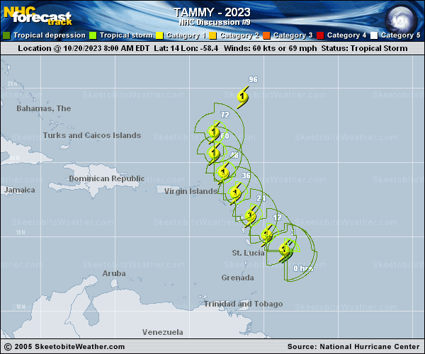
Copy of official data Hurricane Tammy Discussion Number 9 NWS National Hurricane Center Miami FL AL202023 1100 AM AST Fri Oct 20 2023 Recent data from both NOAA and Air Force Reserve Hurricane Hunter aircraft and radar imagery from Barbados shows that the inner core structure of the storm has become much better organized this morning. The radar imagery has depicted strong convection that has quickly evolved into a curved band, and more recently a closed eye. The aircraft data indicates that there is still some tilt to the circulation, but the most recent center fixes indicate that the pressure has fallen quickly to around 992 mb this morning. The plane has reported flight-level winds of 71 kt at 700 mb, and SFMR values of 65-70 kt. Based on these data, the initial intensity has been increased to 65 kt for this advisory, making Tammy a hurricane. Tammy is moving slowly west-northwestward at about 6 kt. The storm should turn northwestward later today as an amplified trough moving off the east coast of the U.S. and into the western Atlantic erodes the western portion of a subtropical ridge over the central Atlantic. This motion is expected to bring the center of Tammy near or over portions of the Leeward Islands tonight and Saturday. The latest track prediction is similar to the previous advisory and lies closest to the HFIP corrected consensus during the first 36-48 hours. After Tammy moves north of the Leeward Islands, the storm is forecast to turn northward and then begin to recurve in the mid-latitude westerlies by days 4 and 5. There is increasing along-track spread in the guidance after 72 hours due to how fast Tammy accelerates northeastward. Much of the guidance has been trending slower, and the official forecast has followed suit. The environment consisting of warm SSTs and light to moderate shear favors some additional strengthening during the next couple of days. The updated NHC intensity forecast calls for strengthening during the next 36-48 hours while Tammy approaches the Leeward Islands. Once Tammy is north of the Leeward Islands, increasing vertical wind shear is likely to limit additional intensification. Near the end of the period, Tammy is likely to begin its extratropical transition, but it is still shown to be a hurricane at day 5. KEY MESSAGES: 1. Hurricane conditions are expected in portions of the Leeward Islands by late tonight or Saturday morning. Tropical storm conditions are expected to begin in portions of the Lesser Antilles within the warning area later today. 2. Heavy rains from Tammy will begin to affect the Leeward and northern Windward Islands later today and into Saturday morning, spreading into the British and U.S. Virgin Islands and Puerto Rico as early as Sunday. This rainfall may produce isolated flash and urban flooding, along with isolated mudslides in areas of higher terrain. 3. A storm surge could produce coastal flooding in areas of onshore winds as the center of Tammy moves near or over the Leeward Islands. Near the coast, the surge will be accompanied by large and dangerous waves. FORECAST POSITIONS AND MAX WINDS INIT 20/1500Z 14.1N 58.6W 65 KT 75 MPH 12H 21/0000Z 15.1N 59.8W 70 KT 80 MPH 24H 21/1200Z 16.4N 60.9W 75 KT 85 MPH 36H 22/0000Z 17.9N 61.9W 75 KT 85 MPH 48H 22/1200Z 19.3N 62.7W 80 KT 90 MPH 60H 23/0000Z 20.6N 63.3W 80 KT 90 MPH 72H 23/1200Z 22.0N 63.3W 80 KT 90 MPH 96H 24/1200Z 24.4N 61.4W 80 KT 90 MPH 120H 25/1200Z 28.2N 57.7W 75 KT 85 MPH $$ Forecaster Brown |