Official Discussion issued by the National Hurricane Center
Tammy (AL202023) DATA RELEASED: 10/20/2023 9:00:00 AM UTC
|
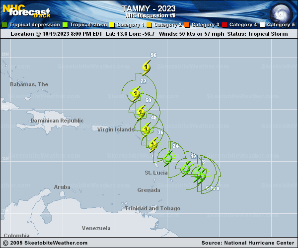
Copy of official data Tropical Storm Tammy Discussion Number 8 NWS National Hurricane Center Miami FL AL202023 500 AM AST Fri Oct 20 2023 Tammy is still an asymmetric tropical storm, although the surface center is embedded beneath a persistent area of deep convection. Radar data from Barbados also suggest that the circulation remains tilted from west to east with height. An Air Force Reserve Hurricane Hunter aircraft investigated Tammy a few hours ago and measured maximum 850-mb flight-level winds of 61 kt and SFMR surface winds around 50 kt, indicating that the storm's intensity remains 50 kt. The central pressure has fallen slightly to 1000 mb. The aircraft center fixes indicate that Tammy has continued to slow down and is moving toward the west-northwest (290 degrees) at 7 kt. An amplified deep-layer trough moving across the eastern United States is beginning to push the Atlantic subtropical ridge eastward, and this pattern evolution should allow Tammy to turn northwestward by this evening, with its center passing very near or over the Leeward Islands tonight and on Saturday. The new NHC forecast is very close to the previous track prediction during the first 36 hours and lies near the HCCA and TVCA consensus aids. After 36 hours, the track guidance has shifted a bit west and slowed down, apparently due to the aforementioned trough lifting to the northeast and leaving Tammy behind. As a result, the official forecast continues to show recurvature over the central Atlantic by day 5, but at a relatively slow forward speed. SHIPS guidance suggests that deep-layer shear over Tammy should decrease a bit over the next 24 hours, but model fields indicate there could be some mid-level shear below the outflow level. Still, environmental conditions appear conducive to support gradual strengthening, and the NHC intensity forecast brings Tammy to hurricane intensity by 36 hours as the center passes near or over the Leeward Islands. It is possible that Tammy could become a hurricane before that time, as suggested by several models including SHIPS, HAFS-B, HWRF, and the HCCA corrected consensus. A peak in intensity is forecast in 3-4 days, before southwesterly vertical shear increases in earnest ahead of the trough. Model fields suggest that extratropical transition could begin toward the end of the forecast period, but for now Tammy is still shown as a hurricane on day 5. KEY MESSAGES: 1. Tammy is expected to strengthen to a hurricane by Saturday while it moves near or over portions of the Leeward Islands. Tropical storm conditions are expected to begin in portions of the Lesser Antilles within the tropical storm warning area this afternoon or evening, with hurricane conditions possible within the hurricane watch area on Saturday. Additional watches and warnings could be required later today. 2. Heavy rains from Tammy will begin to affect the Leeward and northern Windward Islands today, spreading into the British and U.S. Virgin Islands and Puerto Rico over the weekend. This rainfall may produce isolated flash and urban flooding, along with isolated mudslides in areas of higher terrain. FORECAST POSITIONS AND MAX WINDS INIT 20/0900Z 14.0N 58.3W 50 KT 60 MPH 12H 20/1800Z 14.7N 59.4W 55 KT 65 MPH 24H 21/0600Z 15.9N 60.7W 60 KT 70 MPH 36H 21/1800Z 17.3N 61.8W 65 KT 75 MPH 48H 22/0600Z 18.8N 62.6W 70 KT 80 MPH 60H 22/1800Z 20.3N 63.2W 75 KT 85 MPH 72H 23/0600Z 21.7N 63.4W 80 KT 90 MPH 96H 24/0600Z 24.3N 61.9W 80 KT 90 MPH 120H 25/0600Z 27.8N 58.8W 75 KT 85 MPH $$ Forecaster Berg |