Official Discussion issued by the National Hurricane Center
Tammy (AL202023) DATA RELEASED: 10/19/2023 3:00:00 PM UTC
|
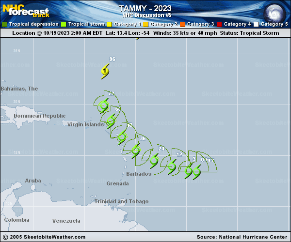
Copy of official data Tropical Storm Tammy Discussion Number 5 NWS National Hurricane Center Miami FL AL202023 1100 AM AST Thu Oct 19 2023 Tammy is a sheared tropical cyclone with the center located on the northwestern edge of the main convective mass. Despite this structure, the storm has strengthened since yesterday. A NOAA Hurricane Hunter aircraft that investigated Tammy this morning found peak 700-mb flight-level winds of 49 kt and peak SFMR winds of 50 kt. Based on these data, the intensity was increased to 50 kt on a Special advisory that was issued at 1200 UTC. The plane did not find any stronger winds since that time, and the initial intensity remains 50 kt for this advisory. An Air Force Reserve reconnaissance aircraft is scheduled to investigate Tammy this afternoon. Tammy is moving west-northwestward or 285 degrees at 13 kt. The storm is forecast to reach the southwestern periphery of a subtropical ridge over the central Atlantic by Friday, and this should cause Tammy to slow down and turn northwestward during the next 24 to 36 hours. This motion is forecast to bring the center of the storm near or over portions of the Leeward Islands late Friday and Saturday. After Tammy moves north of the Leeward Islands, the storm is expected to turn northward around the western side of the ridge. There is still significant spread on exactly when the northwestward turn occurs with the GFS and ECMWF along the right side of the guidance envelope, with some of the regional hurricane models along the left side. The NHC track is near the middle of the guidance envelope closest to the HFIP corrected consensus model. Tammy will be moving over warm SSTS as it nears the Leeward Islands, which should allow for gradual strengthening despite the presence of light to moderate wind shear. Given the current sheared structure, the NHC intensity forecast is a bit more conservative during the first day or two than much of the intensity guidance. Despite that, the updated NHC forecast calls for Tammy to be at or near hurricane strength when it moves near or over the Leeward Islands. Additional strengthening is expected after Tammy moves north of the Leeward Islands and recurves over the central Atlantic. KEY MESSAGES: 1. Tropical storm conditions are expected to begin in portions of the Lesser Antilles on Friday, where a tropical storm warning is in effect. Tropical storm and hurricane conditions are possible elsewhere in the Leeward Islands where hurricane and tropical storm watches are currently in effect. Additional watches and warnings will likely be required later today. 2. Heavy rains from Tammy will begin to affect the northern Windward and Leeward Islands on Friday, spreading into the British and U.S. Virgin Islands and Puerto Rico over the weekend. This rainfall may produce isolated flash and urban flooding, along with isolated mudslides in areas of higher terrain. FORECAST POSITIONS AND MAX WINDS INIT 19/1500Z 13.6N 55.7W 50 KT 60 MPH 12H 20/0000Z 14.0N 57.4W 55 KT 65 MPH 24H 20/1200Z 14.8N 59.2W 60 KT 70 MPH 36H 21/0000Z 16.0N 60.9W 60 KT 70 MPH 48H 21/1200Z 17.5N 62.1W 65 KT 75 MPH 60H 22/0000Z 19.0N 62.8W 70 KT 80 MPH 72H 22/1200Z 20.5N 63.3W 70 KT 80 MPH 96H 23/1200Z 24.0N 62.8W 75 KT 85 MPH 120H 24/1200Z 28.4N 57.9W 75 KT 85 MPH $$ Forecaster Brown |