Official Discussion issued by the National Hurricane Center
Tammy (AL202023) DATA RELEASED: 10/28/2023 3:00:00 PM UTC
|
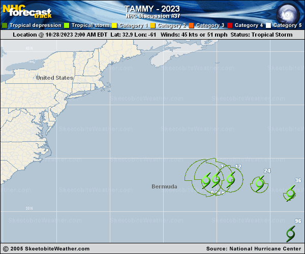
Copy of official data Tropical Storm Tammy Discussion Number 37 NWS National Hurricane Center Miami FL AL202023 1100 AM AST Sat Oct 28 2023 Tammy has not changed much this morning. The impact of strong westerly wind shear is evident, with an exposed low-level center apparent in visible satellite imagery. Modest deep convection remains confined to the eastern half of the circulation, and cloud tops have continued to gradually warm. The subjective TAFB satellite estimate of T3.0/45 kt and a blend of objective satellite estimates continue to support an initial intensity of 45 kt for this advisory. Under the continued influence of strong shear for the next 48 hours, as well as a dry mid-level airmass approaching from the northwest, Tammy is expected to continue weakening. Global and regional models suggest that most of the deep convection will diminish by late Sunday or Monday, at which time Tammy is forecast to become a remnant low. The NHC forecast is similar to the prior forecast and represents a blend of the prior forecast and intensity consensus models. Tammy has accelerated this morning and is now moving east-northeast or 080/10 kt. The tropical storm is expected to continue eastward and southeastward for the next day or so along the northern periphery of a mid-level ridge. Early next week, Tammy and its remnants are forecast to make a gradual turn toward the south and southwest before dissipating. The new NHC forecast is slightly faster than the prior advisory and represents a blend of consensus aids HCCA and TVCN with the prior NHC forecast. FORECAST POSITIONS AND MAX WINDS INIT 28/1500Z 33.3N 58.7W 45 KT 50 MPH 12H 29/0000Z 33.1N 56.4W 40 KT 45 MPH 24H 29/1200Z 32.3N 53.0W 35 KT 40 MPH 36H 30/0000Z 30.9N 50.0W 30 KT 35 MPH...POST-TROP/REMNT LOW 48H 30/1200Z 29.2N 48.6W 30 KT 35 MPH...POST-TROP/REMNT LOW 60H 31/0000Z 27.8N 48.5W 25 KT 30 MPH...POST-TROP/REMNT LOW 72H 31/1200Z 27.1N 49.6W 20 KT 25 MPH...POST-TROP/REMNT LOW 96H 01/1200Z 27.5N 51.7W 20 KT 25 MPH...POST-TROP/REMNT LOW 120H 02/1200Z...DISSIPATED $$ Forecaster Hogsett/Blake |