Official Discussion issued by the National Hurricane Center
Tammy (AL202023) DATA RELEASED: 10/25/2023 9:00:00 AM UTC
|
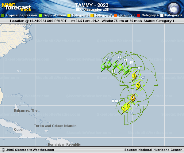
Copy of official data Hurricane Tammy Discussion Number 28 NWS National Hurricane Center Miami FL AL202023 500 AM AST Wed Oct 25 2023 Satellite data indicate Tammy has strengthened this morning. Proxy-vis and infrared imagery depict a ragged eye has developed with deep convection wrapping around the center. There has been no microwave imagery this morning, but earlier SSMI/S and GMI images showed a tight inner core. The subjective Dvorak final-T intensity estimates have increased this cycle with a T5.0 and T4.5 from SAB and TAFB, respectively. Given the improved satellite imagery and using a blend of these estimates, the initial intensity is raised to 85 kt for this advisory. Although vertical wind shear is analyzed to have increased over the hurricane, the system is strengthening beneath upper-level divergence associated with a deep-layer trough over the western Atlantic. Models suggest some additional strengthening is possible over the next 12 hours or so, which is reflected in the NHC intensity forecast. Tammy is then expected to merge with a cold front, which is currently analyzed by TAFB and OPC just northwest of the system. Tammy is expected to undergo an extratropical transition, with this transition forecast to be complete within 24 hours. As this transition occurs Tammy's wind field will expand as it becomes a hurricane-force extratropical cyclone. Global models are in fairly good agreement that the cyclone will then weaken throughout the remainder of the forecast period. There is some potential it could shed its frontal structure this weekend, but for now the model-simulated satellite imagery does not show much increase in convection during that time. Tammy is moving northeastward at an estimated motion of 45 degrees at 9 knots, within the flow between a deep-layer trough over the western Atlantic and a subtropical ridge over the central Atlantic. Tammy is expected to turn northward later today, then move slowly northwestward in 2-3 days within weaker steering currents. The long-range forecast remains uncertain, with not much run-to-run model consistency and ensemble solutions that move in opposite directions. Given the uncertainty, there is little change from the previous forecast at this time range, with the NHC forecast track showing the cyclone slowing and meandering through the end of the the period. FORECAST POSITIONS AND MAX WINDS INIT 25/0900Z 25.6N 60.2W 85 KT 100 MPH 12H 25/1800Z 27.0N 59.4W 90 KT 105 MPH 24H 26/0600Z 28.9N 59.3W 75 KT 85 MPH...POST-TROP/EXTRATROP 36H 26/1800Z 30.0N 60.4W 65 KT 75 MPH...POST-TROP/EXTRATROP 48H 27/0600Z 30.6N 61.6W 60 KT 70 MPH...POST-TROP/EXTRATROP 60H 27/1800Z 31.0N 62.3W 55 KT 65 MPH...POST-TROP/EXTRATROP 72H 28/0600Z 31.3N 62.9W 50 KT 60 MPH...POST-TROP/EXTRATROP 96H 29/0600Z 31.2N 63.5W 45 KT 50 MPH...POST-TROP/EXTRATROP 120H 30/0600Z 31.0N 63.9W 40 KT 45 MPH...POST-TROP/EXTRATROP $$ Forecaster Kelly |