Official Discussion issued by the National Hurricane Center
Tammy (AL202023) DATA RELEASED: 10/24/2023 3:00:00 AM UTC
|
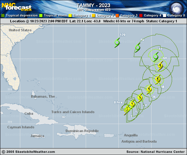
Copy of official data Hurricane Tammy Discussion Number 23 NWS National Hurricane Center Miami FL AL202023 1100 PM AST Mon Oct 23 2023 Microwave data from multiple polar-orbiting satellites received during the last few hours indicate that Tammy still has a well-organized low- to mid-level circulation, even as its deep convection is getting sheared northward. The most recent TAFB Dvorak classification was a 4.0/65 kt, which supports maintaining Tammy as a hurricane. While Tammy's future path remains unusually unclear, especially at the 4-5 day range, very little change was made to the official track forecast. The hurricane is currently moving north-northeastward, and it should get steered northward starting in about 2 days as the hurricane interacts with a mid-latitude trough approaching from the northwest. The uncertainty in the forecast increases considerably after that point as Tammy will likely reach a col point in the steering flow over the western Atlantic. Many models and ensemble members indicate another mid-latitude trough will cause the cyclone to begin to accelerate eastward or northeastward. However, it appears equally likely that Tammy will then turn westward or southwestward under the influence of a mid-level ridge that should build behind the second trough. With no clear reason to support one solution or another, the NHC track forecast is unchanged for now. It remains near the consensus of the GFS and ECMWF through about 72 h, and then favors the ECMWF and ECENS mean after that. Conversely, the intensity forecast appears to be more straightforward. Most of the intensity guidance indicates that slight strengthening is possible during the next day or so, as Tammy gets a convective boost while interacting with an upper-level trough. However, after about 48 h, it should begin to weaken and transition to a post-tropical cyclone. Based on simulated satellite imagery, this process is expected to complete in about 72 h, though Tammy will likely continue to produce gale- to storm-force winds for several days thereafter. FORECAST POSITIONS AND MAX WINDS INIT 24/0300Z 22.9N 63.1W 65 KT 75 MPH 12H 24/1200Z 23.6N 62.2W 70 KT 80 MPH 24H 25/0000Z 24.7N 60.8W 75 KT 85 MPH 36H 25/1200Z 26.5N 59.2W 75 KT 85 MPH 48H 26/0000Z 28.5N 58.3W 75 KT 85 MPH 60H 26/1200Z 30.0N 58.6W 65 KT 75 MPH 72H 27/0000Z 31.1N 59.7W 55 KT 65 MPH...POST-TROP/EXTRATROP 96H 28/0000Z 32.0N 62.0W 50 KT 60 MPH...POST-TROP/EXTRATROP 120H 29/0000Z 32.5N 64.0W 45 KT 50 MPH...POST-TROP/EXTRATROP $$ Forecaster D. Zelinsky |