Official Discussion issued by the National Hurricane Center
Tammy (AL202023) DATA RELEASED: 10/21/2023 3:00:00 AM UTC
|
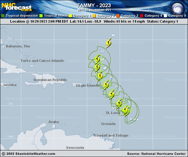
Copy of official data Hurricane Tammy Discussion Number 11 NWS National Hurricane Center Miami FL AL202023 1100 PM AST Fri Oct 20 2023 Although the satellite and radar presentations of Tammy do not appear to have become significantly better organized, with a small CDO and limited convective banding features, reconnaissance aircraft data indicate the hurricane has strengthened slightly. Dropsonde and SFMR-observed surface winds from Air Force and NOAA Hurricane Hunter aircraft support an intensity of 70 kt for this advisory. This is a little above the most recent Dvorak estimates. Center fixes from the Hurricane Hunter aircraft indicate that Tammy is still moving west-northwestward or at about 295/8 kt, so the anticipated northwestward turn has not yet occurred. The hurricane is moving along the southwestern periphery of a large subtropical high pressure area. A strong mid-tropospheric trough moving off the U.S. east coast should erode the western portion of the ridge and cause Tammy to turn northwestward to northward during the next couple of days. However, based on the more westward motion observed by the Hurricane Hunters, the official track forecast has been shifted somewhat to the west of the previous one through 48 hours. This is a little west of the model consensus. The track guidance is not in very good agreement on the movement of Tammy after is passes the northern Leeward Islands. Some of the models, such as the ECMWF, show the system moving quite slowly at 72 hours and beyond. The GFS is an outlier with a more rapid north-northeastward motion. Based on the dynamical model consensus, the NHC track forecast is slower than the previous one in the 3- to 5-day time frame. Tammy should remain in an environment of high oceanic heat content, but with moderate vertical wind shear for the next couple of days. Thus, some modest strengthening is forecast during the next 24 hours, while the system passes near or over portions of the Leeward Islands. The NHC intensity forecast is a little higher than the previous one, and above the simple and corrected model consensus guidance. It should be noted that there is a significant area of deep convection well to the south-southeast of the center which could bring heavy rains to portions of the Lesser Antilles well after the center of the hurricane passes by. KEY MESSAGES: 1. Hurricane conditions are expected in portions of the Leeward Islands by late tonight through Saturday. Tropical storm conditions are expected to begin in portions of the Lesser Antilles within the warning area overnight. 2. Heavy rains from Tammy will affect the Windward and Leeward Islands into Saturday morning, spreading into the British and U.S. Virgin Islands and eastern Puerto Rico as early as Sunday. This rainfall may produce isolated flash and urban flooding, along with isolated mudslides in areas of higher terrain. 3. A storm surge could produce coastal flooding in areas of onshore winds as the center of Tammy moves near or over the Leeward Islands. Near the coast, the surge will be accompanied by large and dangerous waves. FORECAST POSITIONS AND MAX WINDS INIT 21/0300Z 14.7N 60.2W 70 KT 80 MPH 12H 21/1200Z 15.8N 61.0W 75 KT 85 MPH 24H 22/0000Z 17.3N 62.0W 80 KT 90 MPH 36H 22/1200Z 18.8N 63.0W 80 KT 90 MPH 48H 23/0000Z 20.0N 63.8W 80 KT 90 MPH 60H 23/1200Z 21.4N 64.3W 80 KT 90 MPH 72H 24/0000Z 22.4N 64.0W 75 KT 85 MPH 96H 25/0000Z 24.0N 62.5W 70 KT 80 MPH 120H 26/0000Z 27.0N 60.0W 65 KT 75 MPH $$ Forecaster Pasch |