Official Discussion issued by the National Hurricane Center
Sean (AL192023) DATA RELEASED: 10/13/2023 3:00:00 AM UTC
|
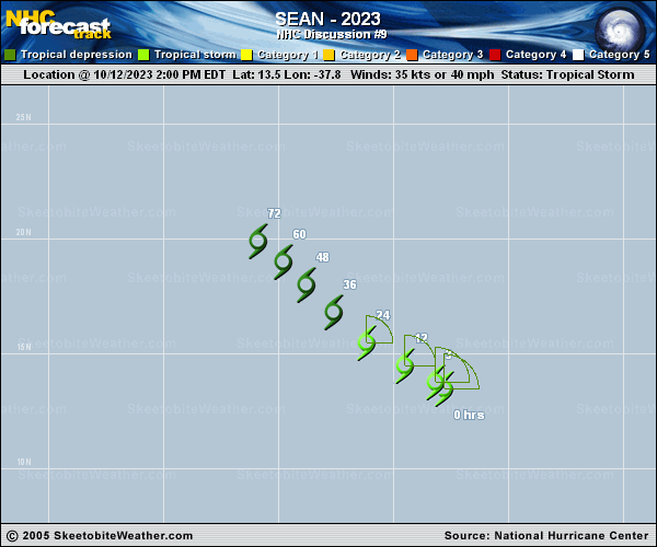
Copy of official data Tropical Storm Sean Discussion Number 9 NWS National Hurricane Center Miami FL AL192023 1100 PM AST Thu Oct 12 2023 Sean continues to be a sheared tropical cyclone. The exposed low-level center is gradually becoming more displaced from the deepest convection in the northeast quadrant. Surprisingly, satellite wind data that partially captured the center of the storm revealed winds of 38-39 kt. Therefore, despite Sean's ragged appearance, the initial intensity is raised to 40 kt for this advisory. The cyclone is accelerating west-northwestward at an estimated 300/12 kt. Sean is being steered by a weak ridge centered over the eastern tropical Atlantic. This ridge is expected to build westward and keep Sean on a west-northwestward to northwestward track with a decrease in forward speed through the forecast period. The guidance envelope is decently clustered, and the latest advisory lies close to the various consensus aids and just south of the previous track forecast. Environmental conditions are generally not conducive for additional strengthening. Persistent moderate-to-strong deep-layer vertical wind shear and an increasingly dry airmass should inhibit further development of the storm. The model guidance envelope shows Sean gradually weakening for the next couple of days. By the end of the weekend, the storm is expected to lose its convective organization and become a remnant low. The latest NHC intensity prediction has been slightly raised in the near-term forecast hours based on Sean's initial intensity. Dissipation is still anticipated within 4 days. FORECAST POSITIONS AND MAX WINDS INIT 13/0300Z 14.1N 39.5W 40 KT 45 MPH 12H 13/1200Z 14.9N 40.8W 40 KT 45 MPH 24H 14/0000Z 16.1N 42.3W 35 KT 40 MPH 36H 14/1200Z 17.3N 43.6W 35 KT 40 MPH 48H 15/0000Z 18.4N 44.7W 30 KT 35 MPH 60H 15/1200Z 19.2N 45.6W 25 KT 30 MPH...POST-TROP/REMNT LOW 72H 16/0000Z 20.1N 46.6W 25 KT 30 MPH...POST-TROP/REMNT LOW 96H 17/0000Z...DISSIPATED $$ Forecaster Bucci |