Official Discussion issued by the National Hurricane Center
Sean (AL192023) DATA RELEASED: 10/12/2023 9:00:00 AM UTC
|
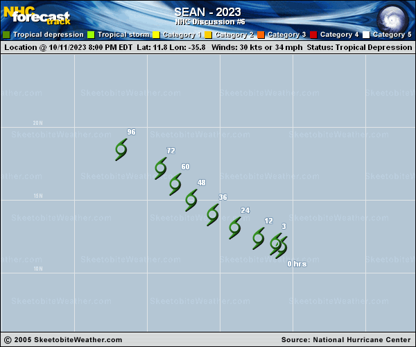
Copy of official data Tropical Depression Sean Discussion Number 6 NWS National Hurricane Center Miami FL AL192023 500 AM AST Thu Oct 12 2023 Sean remains a sheared, poorly organized tropical cyclone. Recent AMSR2 passive microwave images show the surface circulation lies well to the west of the associated deep convection. The lackluster satellite presentation of Sean has resulted in decreasing subjective Dvorak data-T numbers from TAFB and SAB, which supports keeping the system a tropical depression. The initial intensity is held at 30 kt, consistent with the ASCAT data from yesterday evening. The depression is moving west-northwestward at 300/10 kt. A weak low- to mid-level ridge to the north and northeast of Sean should steer the cyclone to the west-northwest and northwest through early next week. A slight rightward adjustment was made to the NHC track forecast to reflect the latest multi-model consensus trends. But otherwise, the updated forecast is similar to the previous prediction. Moderate to strong westerly shear is expected to persist over the depression for the next day or two. By the time the shear relents, simulated satellite images from the GFS and ECMWF models suggest that Sean could struggle to sustain organized convection near its center within a drier and more convergent upper-level environment. While small intensity fluctuations cannot be ruled out during the next couple of days, the NHC intensity forecast follows the HCCA and IVCN aids and keeps Sean a depression through 60 h. Sean is forecast to degenerate to a post-tropical remnant low soon thereafter and dissipate to a trough by day 4, although this could occur even sooner if the cyclone remains poorly organized. FORECAST POSITIONS AND MAX WINDS INIT 12/0900Z 12.5N 36.7W 30 KT 35 MPH 12H 12/1800Z 13.0N 38.0W 30 KT 35 MPH 24H 13/0600Z 13.8N 39.6W 30 KT 35 MPH 36H 13/1800Z 14.8N 41.2W 30 KT 35 MPH 48H 14/0600Z 16.0N 42.6W 30 KT 35 MPH 60H 14/1800Z 17.3N 43.9W 25 KT 30 MPH 72H 15/0600Z 18.2N 45.0W 25 KT 30 MPH...POST-TROP/REMNT LOW 96H 16/0600Z...DISSIPATED $$ Forecaster Reinhart |