Official Discussion issued by the National Hurricane Center
Sean (AL192023) DATA RELEASED: 10/12/2023 3:00:00 AM UTC
|
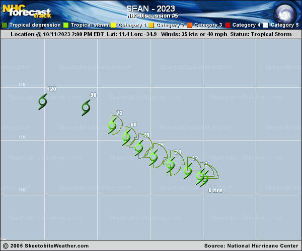
Copy of official data Tropical Depression Sean Discussion Number 5 NWS National Hurricane Center Miami FL AL192023 1100 PM AST Wed Oct 11 2023 Sean is a highly sheared tropical cyclone, with the center located well to the west of the associated deep convection. Similar to what was observed this morning, two recent ASCAT passes showed maximum winds a little over 25 kt and a poorly defined surface circulation. Based on these data, Sean is being designated as a 30-kt tropical depression. The initial motion remains west-northwestward (295 degrees) at 11 kt. Weak mid-level ridging to the north is expected to keep Sean on a west-northwestward or northwestward heading for the next several days, with some decrease in forward speed. The NHC track forecast is very close to the previous prediction through 48 hours, but then deviates a little to the right on days 3 and 4. The GFS and ECMWF are both on the far right side of the guidance envelope, and it's possible that additional rightward adjustments could be possible in subsequent forecasts. Strong deep-layer shear out of the west or west-southwest is expected to continue for the next 36 hours or so, with some abatement possible after that. By then, however, drier air will have infiltrated the circulation, and Sean will begin to struggle to maintain organized deep convection. Due to the hostile atmosphere, and based on the latest intensity guidance, Sean is held as a 30-kt depression for the next 60 hours, with degeneration to a remnant low by day 3. Dissipation to a trough is now forecast by day 5. Some of the global models suggest that each of these transitions could occur even sooner than what is shown in the official forecast. FORECAST POSITIONS AND MAX WINDS INIT 12/0300Z 12.0N 36.2W 30 KT 35 MPH 12H 12/1200Z 12.4N 37.4W 30 KT 35 MPH 24H 13/0000Z 13.1N 39.0W 30 KT 35 MPH 36H 13/1200Z 14.0N 40.5W 30 KT 35 MPH 48H 14/0000Z 15.0N 42.0W 30 KT 35 MPH 60H 14/1200Z 16.1N 43.1W 30 KT 35 MPH 72H 15/0000Z 17.2N 44.1W 25 KT 30 MPH...POST-TROP/REMNT LOW 96H 16/0000Z 18.5N 46.8W 25 KT 30 MPH...POST-TROP/REMNT LOW 120H 17/0000Z...DISSIPATED $$ Forecaster Berg |