Official Discussion issued by the National Hurricane Center
Sean (AL192023) DATA RELEASED: 10/11/2023 3:00:00 PM UTC
|
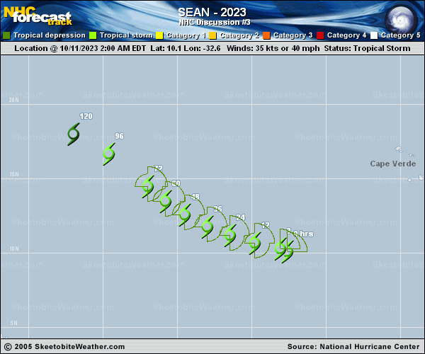
Copy of official data Tropical Storm Sean Discussion Number 3 NWS National Hurricane Center Miami FL AL192023 1100 AM AST Wed Oct 11 2023 This morning, satellite imagery depicts Sean as a rather disorganized tropical storm, with some convective bursting occurring to the northwest and southeast of its elongated center. Subjective satellite intensity estimates from SAB and TAFB are a consensus T2.5/35 kt, and thus the initial intensity is held at 35 kt. An ASCAT-C pass at around 12 UTC suggested that this wind speed value could be a little generous. The intensity is forecast to remain at 35 kt over the first 12 h as the storm already appears embedded in an environment of moderate wind shear. Thereafter, there may be an opportunity for Sean to intensify slightly as it moves into a region of lower wind shear before the current mid-level moisture begin to decrease. By the weekend, the storm is forecast to gradually weaken due to dry air entrainment, and is predicted to become a remnant low by the end of the forecast period. This intensity forecast is in the middle of the guidance envelope for the majority of the forecast period. Sean continues to move west-northwestward at about 11 kt, and is expected to continue moving in this general direction over the next day or two. After 48 hours, the storm will begin to turn more to the northwest and decrease in forward speed as it moves along the southwestern portion of a mid-level ridge to its northeast. By this weekend, a turn back to the west-northwest or west is anticipated as a low- to mid-level ridge re-establishes itself to the north of Sean and it becomes a more shallow cyclone. The NHC track forecast is similar to the previous one and close to the HCCA track guidance. FORECAST POSITIONS AND MAX WINDS INIT 11/1500Z 10.9N 34.4W 35 KT 40 MPH 12H 12/0000Z 11.2N 35.8W 35 KT 40 MPH 24H 12/1200Z 11.7N 37.4W 40 KT 45 MPH 36H 13/0000Z 12.4N 38.9W 40 KT 45 MPH 48H 13/1200Z 13.1N 40.5W 40 KT 45 MPH 60H 14/0000Z 14.1N 41.9W 40 KT 45 MPH 72H 14/1200Z 15.1N 43.0W 35 KT 40 MPH 96H 15/1200Z 16.8N 45.3W 35 KT 40 MPH 120H 16/1200Z 18.1N 48.9W 30 KT 35 MPH...POST-TROP/REMNT LOW $$ Forecaster Camposano/Cangialosi |