Official Discussion issued by the National Hurricane Center
Sean (AL192023) DATA RELEASED: 10/15/2023 9:00:00 AM UTC
|
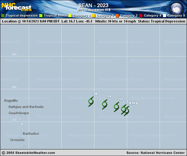
Copy of official data Tropical Depression Sean Discussion Number 18 NWS National Hurricane Center Miami FL AL192023 500 AM AST Sun Oct 15 2023 Deep convection associated with Sean has dissipated overnight, and within the past hour or so the circulation center has become easier to pinpoint as the mid- and high-level clouds that were obscuring it have thinned. The latest Dvorak Current Intensity (CI) numbers from both TAFB and SAB are T2.0/30 kt but the Data-T numbers have fallen even more. Based on the Dvorak CI numbers Sean's initial intensity is held at 30 kt, but this could be generous. Although Sean is located within an area of relatively low vertical wind shear and over warm waters, a surrounding dry mid-level environment is expected to cause weakening during the next day or so. The system may continue to produce intermittent bursts of convection, but these are likely to become less persistent and even less organized than they have been over the past day or so. As a result, the NHC forecast now calls for Sean to degenerate into a remnant low as soon as today. An alternate scenario is that Sean continues to produce enough organized convection to remain a tropical depression until the small circulation opens up into a trough in a day or so. Sean appears to have turned west-northwestward. As the cyclone weakens and becomes increasingly vertically shallow, its motion is forecast to bend westward within the low-level steering flow. The NHC track is similar to the previous advisory and is near the middle of the latest guidance envelope. FORECAST POSITIONS AND MAX WINDS INIT 15/0900Z 17.4N 46.2W 30 KT 35 MPH 12H 15/1800Z 17.7N 47.3W 25 KT 30 MPH...POST-TROP/REMNT LOW 24H 16/0600Z 18.0N 49.4W 25 KT 30 MPH...POST-TROP/REMNT LOW 36H 16/1800Z 18.1N 51.7W 20 KT 25 MPH...POST-TROP/REMNT LOW 48H 17/0600Z...DISSIPATED $$ Forecaster Brown |