Official Discussion issued by the National Hurricane Center
Sean (AL192023) DATA RELEASED: 10/15/2023 3:00:00 AM UTC
|
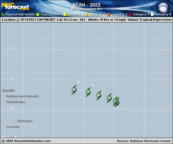
Copy of official data Tropical Depression Sean Discussion Number 17 NWS National Hurricane Center Miami FL AL192023 1100 PM AST Sat Oct 14 2023 Deep convection continues to burst near Sean's center, and as a result, Dvorak estimates from TAFB and SAB remain T2.0/30 kt. In addition, a recent ASCAT-B pass showed winds a little over 25 kt, and all these estimates support maintaining Sean as a 30-kt tropical depression. With relatively low vertical shear, warm sea surface temperatures of 28-29 degrees Celsius, and an unstable atmosphere, the environment is just conducive enough for additional bursts of convection. The biggest limiting factor is a lack of mid-level moisture, with relative humidities running about 50 percent. Consequently, the convection is likely to become less persistent and less organized, and global models indicate that Sean's small circulation should open up into a trough over the next day or two. The NHC forecast shows Sean degenerating into a remnant low in 24 hours and then dissipating by 48 hours, but it's also possible that the system remains a tropical depression right up until it opens up into a trough. Sean continues to move northwestward, or 305/7 kt. As it becomes a weaker system, the depression is expected to become increasingly steered by lower-level ridging. As a result, Sean is expected to turn west-northwestward overnight and then westward by early Monday, just before or as it degenerates into a trough. The NHC track forecast is very close to the previous prediction and the latest TVCA multi-model consensus. FORECAST POSITIONS AND MAX WINDS INIT 15/0300Z 16.9N 45.5W 30 KT 35 MPH 12H 15/1200Z 17.3N 46.6W 30 KT 35 MPH 24H 16/0000Z 17.7N 48.4W 25 KT 30 MPH...POST-TROP/REMNT LOW 36H 16/1200Z 18.1N 50.5W 25 KT 30 MPH...POST-TROP/REMNT LOW 48H 17/0000Z...DISSIPATED $$ Forecaster Berg |