Official Discussion issued by the National Hurricane Center
Sean (AL192023) DATA RELEASED: 10/14/2023 9:00:00 PM UTC
|
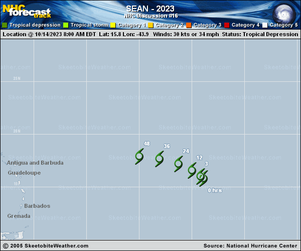
Copy of official data Tropical Depression Sean Discussion Number 16 NWS National Hurricane Center Miami FL AL192023 500 PM AST Sat Oct 14 2023 Sean has had another deep convective burst near the center of circulation this afternoon. The system continues to fend off dry air with these convective burst from time to time. Latest subjective Dvorak intensity satellite estimates are T2.0 from both TAFB and SAB. Using these estimates and the recent burst of convection the initial intensity for this advisory remains 30 kt. Sean is moving northwestward or 310 degrees at about 8 kt. The system will continue to move northwestward today and tonight around the southwestern periphery of a mid-level ridge. On Sunday, a turn toward the west-northwest is anticipated as Sean is forecast to weaken into a more shallow vortex, and thus will be steered by the low-level flow. This turn is dependent on just how quickly Sean weakens. The NHC forecast is an update of the previous one, with no real changes to the forecast track. Although Sean is moving into a drier mid-level airmass, low wind shear and warm sea surface temperatures have allowed the system to maintain convective bursts the past day or so. Along the forecast track, the environment is forecast to become increasingly drier and more stable. This should cause Sean to further weaken the next couple of days. Global models continue to depict that Sean will struggle to produce deep convection tonight and into Sunday. The system is forecast to be devoid of convection and become a remnant low in about 24 hours, and then the circulation is expected to open up into a trough and dissipate in about 60 hours. FORECAST POSITIONS AND MAX WINDS INIT 14/2100Z 16.5N 44.8W 30 KT 35 MPH 12H 15/0600Z 17.0N 45.8W 30 KT 35 MPH 24H 15/1800Z 17.5N 47.5W 25 KT 30 MPH...POST-TROP/REMNT LOW 36H 16/0600Z 18.0N 49.3W 25 KT 30 MPH...POST-TROP/REMNT LOW 48H 16/1800Z 18.4N 51.6W 25 KT 30 MPH...POST-TROP/REMNT LOW 60H 17/0600Z...DISSIPATED $$ Forecaster Kelly |