Official Discussion issued by the National Hurricane Center
Sean (AL192023) DATA RELEASED: 10/14/2023 3:00:00 AM UTC
|
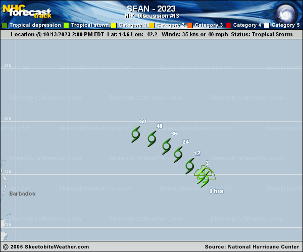
Copy of official data Tropical Storm Sean Discussion Number 13 NWS National Hurricane Center Miami FL AL192023 1100 PM AST Fri Oct 13 2023 Sean is still showing signs of life with a recent burst of convection in the northeast quadrant obscuring the surface circulation. Unfortunately, no new satellite surface wind data is available this evening. Objective and subjective Dvorak estimates range between 25-45 kt. The initial intensity is held at a possibly generous 35 kt, which is closest to the TAFB final T-number of T2.5. The storm has noticeably slowed since the last advisory, with an estimated motion of 290/7 kt. The model guidance continues to insist Sean will turn northwestward on the southwest side of a weak ridge over the eastern Atlantic. However, this has yet to occur. As the cyclone weakens and becomes more shallow, it is expected to bend back to west-northwest. Once again, the latest NHC track forecast was shifted south of the previous prediction, and favors the southern side of the guidance envelope due to the recent northward bias of the models. There have been no changes to the official intensity forecast. Sean is expected to continue to weaken in the relatively hostile atmospheric conditions and become a remnant low later this weekend. Most model guidance shows the storm opening into a trough early next week, and the NHC forecast shows dissipation on Monday. FORECAST POSITIONS AND MAX WINDS INIT 14/0300Z 15.1N 42.9W 35 KT 40 MPH 12H 14/1200Z 15.8N 43.8W 30 KT 35 MPH 24H 15/0000Z 16.7N 44.9W 30 KT 35 MPH 36H 15/1200Z 17.5N 46.2W 25 KT 30 MPH...POST-TROP/REMNT LOW 48H 16/0000Z 18.0N 47.7W 25 KT 30 MPH...POST-TROP/REMNT LOW 60H 16/1200Z 18.4N 49.1W 25 KT 30 MPH...POST-TROP/REMNT LOW 72H 17/0000Z...DISSIPATED $$ Forecaster Bucci |