Official Discussion issued by the National Hurricane Center
Sean (AL192023) DATA RELEASED: 10/13/2023 3:00:00 PM UTC
|
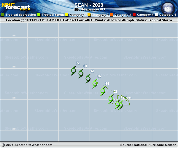
Copy of official data Tropical Storm Sean Discussion Number 11 NWS National Hurricane Center Miami FL AL192023 1100 AM AST Fri Oct 13 2023 Sean's structure and overall satellite appearance have begun to degrade. Deep convection associated with the tropical storm is limited in both strength and coverage as a result of dry surrounding air and continued westerly wind shear, and has decreased noticeably in the last few hours. Recent intensity estimates range from about 25 to 45 kt, but are generally lower than they were for the previous advisory. The initial intensity is therefore lowered to 35 kt for this advisory. Continued gradual weakening is expected for the next several days as Sean moves through a stable environment. Simulated satellite output from several models suggests that Sean may continue to produce occasional bursts of convection for another day or two, but these should become less organized in time. This should cause Sean to become a post-tropical remnant low by Sunday, but recent trends suggest this could happen much sooner. Sean's wind's should gradually decrease as its convection wanes, and it is forecast to open into a trough by Monday. The tropical storm has continued to move west-northwestward for the last few hours. A turn northwestward is forecasted by every available dynamical model and is expected to begin at any time, but since Sean hasn't turned yet, the NHC track forecast had to be adjusted westward again with this advisory. Otherwise, no significant changes were made to the forecast reasoning, with the models in good agreement on Sean's track for the next few days until it dissipates. FORECAST POSITIONS AND MAX WINDS INIT 13/1500Z 14.6N 41.7W 35 KT 40 MPH 12H 14/0000Z 15.3N 42.6W 35 KT 40 MPH 24H 14/1200Z 16.6N 44.0W 30 KT 35 MPH 36H 15/0000Z 17.5N 45.0W 30 KT 35 MPH 48H 15/1200Z 18.1N 46.1W 25 KT 30 MPH...POST-TROP/REMNT LOW 60H 16/0000Z 18.6N 47.5W 25 KT 30 MPH...POST-TROP/REMNT LOW 72H 16/1200Z...DISSIPATED $$ Forecaster D. Zelinsky |