Official Discussion issued by the National Hurricane Center
Rina (AL182023) DATA RELEASED: 10/1/2023 9:00:00 AM UTC
|
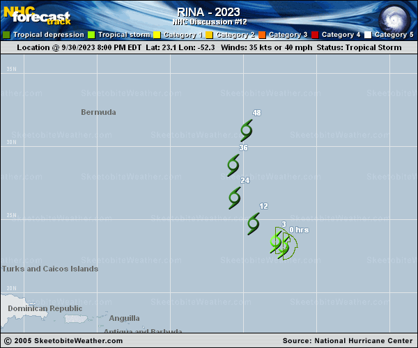
Copy of official data Tropical Storm Rina Discussion Number 12 NWS National Hurricane Center Miami FL AL182023 500 AM AST Sun Oct 01 2023 Strong northwesterly shear continues to take a toll on Rina. The cyclone has been producing an area of deep convection overnight, but it is disorganized and located well southeast of the exposed center. Any convection that has occurred near the center during the past 12-18 hours has been very short-lived. Given the tight circulation that is noted in infrared satellite imagery, the initial wind speed is held at a possibly generous 35 kt for this advisory. Scatterometer data later this morning should help to determine if Rina is still producing tropical-storm-force winds. Environmental conditions consisting of moderate to strong vertical wind shear and dry mid-level air should cause gradual weakening during the next day or two. Rina is forecast to become a remnant low later today or tonight, and the global models indicate that the circulation will open up into a trough of low pressure and dissipate within a couple of days. Rina is moving northwestward at about 12 kt. The cyclone is expected to turn northward later today as it is steered between a low- to mid-level ridge to its northeast and a mid-tropospheric trough over the western Atlantic. The latest NHC track forecast is near the center of the guidance envelope, which is slightly east of the previous advisory. FORECAST POSITIONS AND MAX WINDS INIT 01/0900Z 24.3N 53.7W 35 KT 40 MPH 12H 01/1800Z 25.6N 55.0W 30 KT 35 MPH...POST-TROP/REMNT LOW 24H 02/0600Z 27.7N 55.4W 25 KT 30 MPH...POST-TROP/REMNT LOW 36H 02/1800Z 30.4N 54.3W 25 KT 30 MPH...POST-TROP/REMNT LOW 48H 03/0600Z...DISSIPATED $$ Forecaster Brown |