Official Discussion issued by the National Hurricane Center
Philippe (AL172023) DATA RELEASED: 9/30/2023 9:00:00 PM UTC
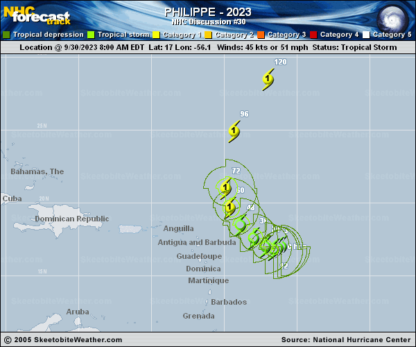
|
Copy of official data Tropical Storm Philippe Discussion Number 30 NWS National Hurricane Center Miami FL AL172023 500 PM AST Sat Sep 30 2023 Philippe remains a sheared tropical cyclone. Its low-level center has become increasingly separated from the deep convection today. Visible satellite images and and fixes from the Air Force Hurricane Hunters indicate the center is farther south and slightly east of our previous estimates. In terms of Philippe's current intensity, there were mixed signals in the aircraft data. The peak 850-mb flight-level winds were only 49 kt, and a center dropsonde indicated no change of the minimum pressure (999 mb) since the previous flight. On the other hand, the SFMR retrievals showed winds of 45-50 kt outside of convection that were visually supported by the flight crew, but a coincident dropsonde reported much lower near-surface wind speeds. Given the conflicting data and less impressive satellite presentation, the initial intensity is held at 45 kt. The tropical storm has continued to move southwestward today, with an initial motion of 215/4 kt. In the near term, the models suggest Philippe will not move very much and could drift erratically through early Sunday while Tropical Storm Rina passes to its north. Then, there is general agreement that the storm will turn toward the west-northwest and northwest around the western extent of a low- to mid-level ridge over the central Atlantic. While there is still a large spread in the track guidance during the 24-72 h time frame, it is noteworthy that the 12z ECMWF has trended eastward this cycle and shows Philippe passing farther east of the northern Leeward Islands. The latest NHC track forecast is slightly farther south and west early in the forecast due to the center relocation. However, the updated prediction ends up near or slightly east of the previous forecast at 36-72 h, in best agreement with the TVCA simple consensus. By days 4-5, Philippe is forecast to accelerate northward and northeastward between a central Atlantic ridge and a deep-layer trough over the western Atlantic. Only modest strengthening is forecast during the next 24-36 h while Philippe contends with moderate to strong northwesterly shear. The upper-level winds are forecast to become more conducive for intensification in a couple of days or so, which should allow the cyclone to become more vertically aligned and establish an inner core. Thus, more strengthening is forecast at days 2-4 while Philippe moves over the very warm SSTs of the central Atlantic, which is supported by almost all of the intensity guidance. The NHC forecast calls for Philippe to become a hurricane by 60 h with continued strengthening thereafter. The peak intensity was raised to bring the NHC forecast slightly closer to the latest HCCA and IVCN aids at days 4-5, but it is noted that the regional hurricane models are even stronger than the current NHC forecast. FORECAST POSITIONS AND MAX WINDS INIT 30/2100Z 16.3N 56.5W 45 KT 50 MPH 12H 01/0600Z 16.2N 56.7W 50 KT 60 MPH 24H 01/1800Z 16.6N 57.4W 55 KT 65 MPH 36H 02/0600Z 17.4N 58.1W 55 KT 65 MPH 48H 02/1800Z 18.5N 58.9W 60 KT 70 MPH 60H 03/0600Z 19.9N 59.5W 65 KT 75 MPH 72H 03/1800Z 21.6N 59.7W 70 KT 80 MPH 96H 04/1800Z 25.7N 59.0W 80 KT 90 MPH 120H 05/1800Z 29.5N 56.0W 80 KT 90 MPH $$ Forecaster Reinhart |