Official Discussion issued by the National Hurricane Center
Philippe (AL172023) DATA RELEASED: 9/28/2023 9:00:00 PM UTC
|
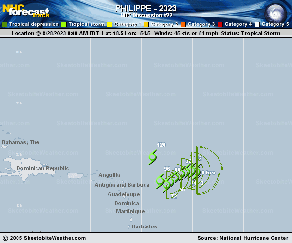
Copy of official data Tropical Storm Philippe Discussion Number 22 NWS National Hurricane Center Miami FL AL172023 500 PM AST Thu Sep 28 2023 Philippe remains poorly organized. Visible satellite images indicate that the circulation is elongated from east to west and appears to have multiple centers along a trough axis. The center position listed in the advisory seems to be the main center and there is some deep convection on its east and southeast sides. Philippe barely meets the criteria needed for a tropical cyclone as it has lost some organization today. The initial intensity is lowered to 40 kt, which is near the high end of the latest satellite intensity estimates. The initial motion is highly uncertain since the storm is elongated and confidence in the initial position remains low. The track forecast is challenging, in part due to Philippe's close proximity to Tropical Storm Rina. During the next few days, Philippe will likely move slowly southwestward as it rotates around Rina currently to its east. By late in the weekend, however, a sharp northward turn is expected when a mid-level ridge becomes established over the central subtropical Atlantic. There remains a very large east-west spread in the models, and disagreements on where Philippe makes its northward turn. The GFS is the right-most model while the ECMWF remains the model farthest west. The NHC track forecast is little changed from the previous one and remains closest to the ECMWF model, which has been performing best so far for this storm. The observed weakening of the system today appears to be related to its interaction with Rina and some environmental dry air. Since these factors are expected to persist, some additional weakening is forecast during the next day or so, and it is possible that Philippe dissipates sometime during the next couple of days. However, if the storm does survive, environmental conditions are expected to become a little more favorable when Philippe and Rina become more separated later in the forecast period. There is a huge spread in the intensity models with HWRF, HMON, and the GFS showing Philippe becoming a significant hurricane while the HAFS-A and HAFS-B models show gradual weakening. The NHC intensity forecast is a little lower than the previous one in the short term, but is otherwise unchanged and closer to the low end of the model guidance. FORECAST POSITIONS AND MAX WINDS INIT 28/2100Z 18.9N 55.1W 40 KT 45 MPH 12H 29/0600Z 18.9N 55.5W 35 KT 40 MPH 24H 29/1800Z 18.7N 55.9W 35 KT 40 MPH 36H 30/0600Z 18.3N 56.2W 40 KT 45 MPH 48H 30/1800Z 17.9N 56.4W 45 KT 50 MPH 60H 01/0600Z 17.5N 57.0W 45 KT 50 MPH 72H 01/1800Z 17.0N 57.6W 45 KT 50 MPH 96H 02/1800Z 18.6N 58.6W 45 KT 50 MPH 120H 03/1800Z 20.6N 59.1W 40 KT 45 MPH $$ Forecaster Cangialosi |