Official Discussion issued by the National Hurricane Center
Philippe (AL172023) DATA RELEASED: 9/23/2023 9:00:00 PM UTC
|
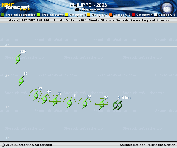
Copy of official data Tropical Storm Philippe Discussion Number 2 NWS National Hurricane Center Miami FL AL172023 500 PM AST Sat Sep 23 2023 Overall, the structure of the cyclone hasn't changed significantly since this morning. Its low-level center is still displaced west of most of the associated deep convection. That said, satellite intensity estimates are generally a little higher than they were about 6 hours ago, ranging from about 30 to 35 kt. The intensity is set at 35 kt, in best agreement with the latest subjective TAFB Dvorak estimate and the objective UW-CIMSS DMINT and SATCON, making the system Tropical Storm Philippe. Philippe is expected to maintain its general structure for the next couple of days, which should prevent it from substantially strengthening. While the intensity guidance is generally slightly higher than 6 h ago, the dynamical models remain in generally good agreement on the intensity forecast for the next few days. Beyond 72 h, Philippe will approach a mid- to upper-level trough, which could result in an increase of both upper-level difluence and deep-layer shear. Slight additional intensification is possible at that point, but no periods of significant strengthening are expected during the next 5 days. The official intensity forecast remains near the IVCN and HCCA intensity consensus aids. The tropical storm continues to move westward, near 12 kt. This should generally continue for the next couple of days until Philippe approaches the aforementioned trough. At that point, as long as the tropical storm has strengthened slightly as expected, it should begin to turn northwestward, and then northward, influenced by the deeper-layer steering flow imparted by the trough. The official track forecast has been shifted slightly northeastward and slower compared to the previous one, and is close to the latest HCCA forecast. FORECAST POSITIONS AND MAX WINDS INIT 23/2100Z 15.6N 39.7W 35 KT 40 MPH 12H 24/0600Z 15.7N 41.6W 40 KT 45 MPH 24H 24/1800Z 15.9N 43.8W 40 KT 45 MPH 36H 25/0600Z 16.3N 46.0W 40 KT 45 MPH 48H 25/1800Z 16.7N 48.3W 45 KT 50 MPH 60H 26/0600Z 17.2N 50.0W 45 KT 50 MPH 72H 26/1800Z 18.0N 51.4W 50 KT 60 MPH 96H 27/1800Z 21.0N 53.5W 55 KT 65 MPH 120H 28/1800Z 24.0N 54.0W 60 KT 70 MPH $$ Forecaster D. Zelinsky |