Official Discussion issued by the National Hurricane Center
Philippe (AL172023) DATA RELEASED: 9/27/2023 3:00:00 AM UTC
|
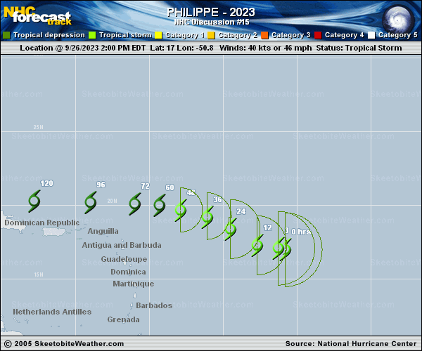
Copy of official data Tropical Storm Philippe Discussion Number 15 NWS National Hurricane Center Miami FL AL172023 1100 PM AST Tue Sep 26 2023 After the previous advisory, there was a convective burst with cloud tops as cold as -80C that formed near the circulation center. More recently, this burst has been waning in intensity, and it would not be surprising to see the vortex become exposed again shortly as 20-30 kt southwesterly vertical wind shear continues. While subjective and objective intensity estimates continue to suggest a weaker storm, a helpful 0015 UTC ASCAT-B pass still showed a large region of 35-40 kt winds in the northeastern side of the circulation, in fact requiring an expansion of the tropical storm force winds in that quadrant. Based primarily on the scatterometer data, Philippe's intensity remains 40 kt for this advisory. The intensity forecast appears rather straightforward. The current vertical wind shear over Philippe is expected to continue through most of the forecast period, helping to import drier air into the circulation, that should prevent additional convective bursts from organizing the system. By 72 hours, both the GFS and ECMWF are in agreement that Philippe should no longer have organized deep convection, which is when the forecast shows the system becoming a post-tropical remnant low. As mentioned previously, this could happen sooner than forecasted given the unfavorable environment. After moving south of due west earlier today, Philippe appears to have resumed a north of due west heading, estimated at 280/10 kt. The track guidance is in good agreement on this motion continuing with a bend westward in 36-48 hours as the cyclone becomes primarily steered by the low-level flow. The latest NHC track forecast remains along or just south of the model guidance consensus aids, and is between the GFS and ECMWF solutions. FORECAST POSITIONS AND MAX WINDS INIT 27/0300Z 17.4N 52.0W 40 KT 45 MPH 12H 27/1200Z 17.9N 53.4W 40 KT 45 MPH 24H 28/0000Z 18.8N 55.2W 35 KT 40 MPH 36H 28/1200Z 19.4N 56.8W 35 KT 40 MPH 48H 29/0000Z 19.8N 58.3W 35 KT 40 MPH 60H 29/1200Z 20.0N 59.8W 30 KT 35 MPH 72H 30/0000Z 20.0N 61.5W 30 KT 35 MPH...POST-TROP/REMNT LOW 96H 01/0000Z 20.1N 64.7W 25 KT 30 MPH...POST-TROP/REMNT LOW 120H 02/0000Z 20.2N 67.0W 25 KT 30 MPH...POST-TROP/REMNT LOW $$ Forecaster Papin |