Official Discussion issued by the National Hurricane Center
Philippe (AL172023) DATA RELEASED: 9/26/2023 9:00:00 AM UTC
|
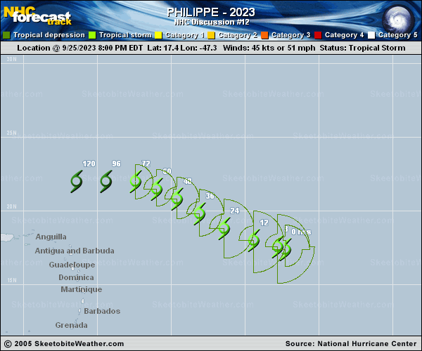
Copy of official data Tropical Storm Philippe Discussion Number 12 NWS National Hurricane Center Miami FL AL172023 500 AM AST Tue Sep 26 2023 West-southwesterly vertical wind shear, associated with an upper-level low near 26N 50W, continues to affect Philippe. The low-level center of the tropical cyclone is located near the western edge of an area of rather disorganized deep convection. Some sporadic convection has been redeveloping nearer to the center of the system, but overall Philippe's cloud pattern remains disheveled in appearance and lacks banding features. The current intensity estimate is kept at 45 kt in deference to the earlier scatterometer data. However, subjective and objective Dvorak intensity estimates are somewhat lower. The global models indicate that the vertical shear over Philippe is not likely to abate significantly during the forecast period, with upper-tropospheric westerlies dominating the flow to the north and northeast of the Greater Antilles through 120 hours. Also, the model guidance indicates that Philippe will be encountering a somewhat drier low- to mid-level air mass during the next several days. These environmental factors should lead to gradual weakening, and thus Philippe is forecast to become a depression and then a remnant low in 3 and 5 days, respectively. This is in good agreement with the corrected consensus intensity model, HCCA, guidance. Over the past day or so, the storm has been moving westward to west-northwestward and the current motion estimate is 285/11 kt. A weak mid-level ridge is expected to be maintained to the north of Philippe for the next few days, which is likely to keep steering the cyclone on a generally west-northwestward track. Later in the forecast period, Philippe should be a weaker, shallower system and move on a mainly westward heading, following the low-level easterly flow. The official track forecast is similar to the previous NHC track, only a little to the left and slightly faster in 3-5 days. This lies between the model consensus and the latest ECMWF prediction, which is even faster and a little farther south. FORECAST POSITIONS AND MAX WINDS INIT 26/0900Z 17.7N 49.0W 45 KT 50 MPH 12H 26/1800Z 18.2N 50.4W 45 KT 50 MPH 24H 27/0600Z 19.1N 52.1W 45 KT 50 MPH 36H 27/1800Z 20.1N 53.9W 45 KT 50 MPH 48H 28/0600Z 21.0N 55.4W 40 KT 45 MPH 60H 28/1800Z 21.6N 56.9W 40 KT 45 MPH 72H 29/0600Z 21.9N 58.2W 35 KT 40 MPH 96H 30/0600Z 21.8N 60.9W 30 KT 35 MPH 120H 01/0600Z 21.8N 63.6W 25 KT 30 MPH...POST-TROP/REMNT LOW $$ Forecaster Pasch |