Official Discussion issued by the National Hurricane Center
Ophelia (AL162023) DATA RELEASED: 9/23/2023 3:00:00 PM UTC
|
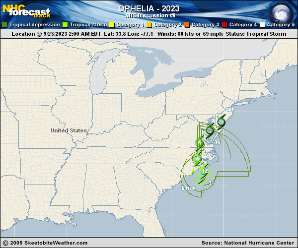
Copy of official data Tropical Storm Ophelia Discussion Number 9 NWS National Hurricane Center Miami FL AL162023 1100 AM EDT Sat Sep 23 2023 Since Ophelia made landfall earlier this morning, the tropical storm has maintained a healthy appearance in radar reflectivity from both the Morehead City and Raleigh radars, though the Doppler wind velocities have steadily decreased as it moves further inland. 1-minute GOES-16 visible imagery depicts curved banding near the center of Ophelia, though the coldest cloud tops on infrared imagery have warmed from last night. The Doppler velocity data and surface observations suggest that maximum sustained winds are down to 45 kt this advisory, though this could be somewhat generous. However, Ophelia continues to produce a large swath of heavy rainfall both near and north of the current storm position, where a large region of Flood Watches and Warnings remain in effect. The tropical storm appears to have accelerated this morning, with the latest estimated motion at 355/11 kt. Over the next 12-24 hours, Ophelia is expected to begin turning northeastward as it moves into southeastern Virginia by this evening. This motion should slow a bit as it becomes tangled up in a frontal boundary moving into the Delmarva Peninsula and off the mid-Atlantic coastline on Sunday. The track forecast this cycle is quite similar to the prior advisory, in best agreement with the simple and corrected track guidance. Continued weakening is expected as Ophelia continues to move inland across eastern North Carolina and then southeastern Virginia. On Sunday, Ophelia's circulation is forecast to become increasingly elongated as interacts with a pre-existing frontal boundary offshore of the Mid-Atlantic coastline. Most of the model guidance shows Ophelia merging with the baroclinic zone in about 24 hours, marking its transition to an extratropical cyclone, with the low ultimately being absorbed by the frontal zone in 48-60 h, though this could occur sooner. Key Messages: 1. Tropical storm conditions will continue along portions of the southeastern and mid-Atlantic U.S. coasts within the Tropical Storm Warning area today. 2. There is a danger of life-threatening storm surge inundation over portions of eastern North Carolina and southeastern Virginia, including Pamlico and Albemarle Sounds, the Neuse and Pamlico Rivers, the lower James River, and the lower Chesapeake Bay, where Storm Surge Warnings are in place. Residents in these areas should follow advice given by local officials. 3. Heavy rainfall from Ophelia may produce locally considerable flash, and urban flooding impacts across portions of the Mid-Atlantic states from North Carolina to New Jersey through Sunday. 4. Swells generated by this system will affect much of the U.S. east coast through the weekend, likely causing life-threatening surf and rip currents. FORECAST POSITIONS AND MAX WINDS INIT 23/1500Z 35.6N 77.2W 45 KT 50 MPH 12H 24/0000Z 36.8N 77.3W 35 KT 40 MPH...INLAND 24H 24/1200Z 38.2N 76.6W 30 KT 35 MPH...POST-TROP/EXTRATROP 36H 25/0000Z 39.1N 75.1W 30 KT 35 MPH...POST-TROP/EXTRATROP 48H 25/1200Z 39.3N 73.0W 25 KT 30 MPH...POST-TROP/EXTRATROP 60H 26/0000Z...DISSIPATED $$ Forecaster Papin |