Official Discussion issued by the National Hurricane Center
Nigel (AL152023) DATA RELEASED: 9/17/2023 3:00:00 PM UTC
|
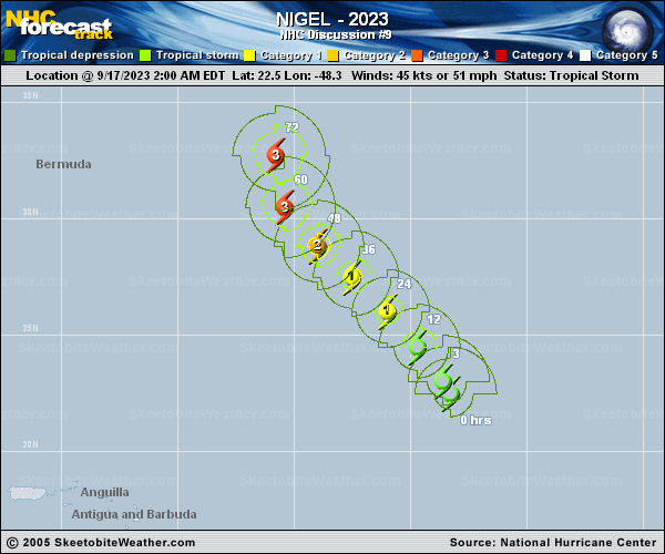
Copy of official data Tropical Storm Nigel Discussion Number 9 NWS National Hurricane Center Miami FL AL152023 1100 AM AST Sun Sep 17 2023 Based on satellite imagery, Nigel appears to be steadily strengthening. A prominent curved band of deep convection wraps around the northern half of the tropical storm, with additional convective activity recently observed very near its center. Satellite intensity estimates range from around 45 to 55 kt, so the initial intensity is set at a near-consensus value of 50 kt. Nigel is in an environment that should support strengthening, and in fact the SHIPS-RII and DTOPS rapid intensification models indicate it has a near 50/50 chance of strengthening 25 kt in the next 24 h and/or 55 kt in the next 48 h. Recent SSMIS imagery at 0911 UTC indicated that the inner core of Nigel is probably not yet well-enough developed to support immediate rapid intensification, but that could happen at some point later today. Most of the intensity models indicate that Nigel's intensity will peak in about 60 h, before increasing wind shear and cooler waters begin to affect it. Extratropical transition should then begin in about 4 days, and that process will likely be near complete at the end of the forecast period. Only very small adjustments were made to the NHC intensity forecast, which is very near the IVCN intensity consensus. Likewise, nearly no changes were made to the official track forecast. For the next 4-5 days, Nigel should generally move between a ridge centered between Nigel and Margot, and a mid-latitude trough that is forecast to move off the eastern coasts of the U.S. and Canada early this week. These features will likely steer Nigel generally northwestward for the next 2 days, and cause it to accelerate northeastward after that. The NHC track forecast continues to be based primarily on the HCCA and TVCN models. FORECAST POSITIONS AND MAX WINDS INIT 17/1500Z 24.0N 49.1W 50 KT 60 MPH 12H 18/0000Z 25.3N 50.2W 60 KT 70 MPH 24H 18/1200Z 26.8N 51.7W 75 KT 85 MPH 36H 19/0000Z 28.2N 53.1W 85 KT 100 MPH 48H 19/1200Z 29.8N 54.6W 95 KT 110 MPH 60H 20/0000Z 31.8N 55.4W 100 KT 115 MPH 72H 20/1200Z 34.2N 54.9W 95 KT 110 MPH 96H 21/1200Z 39.6N 49.0W 85 KT 100 MPH 120H 22/1200Z 46.5N 35.5W 65 KT 75 MPH $$ Forecaster D. Zelinsky |