Official Discussion issued by the National Hurricane Center
Nigel (AL152023) DATA RELEASED: 9/17/2023 9:00:00 AM UTC
|
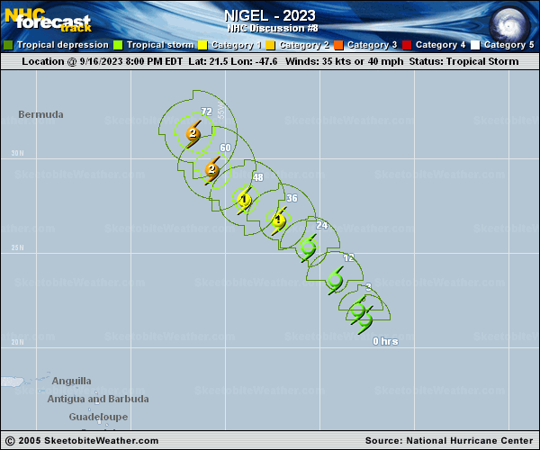
Copy of official data Tropical Storm Nigel Discussion Number 8 NWS National Hurricane Center Miami FL AL152023 500 AM AST Sun Sep 17 2023 Nigel's satellite structure has improved overnight as deep convection has taken on a distinct curved band appearance to the north of the estimated center. With that said, we have not received any recent microwave imagery to confirm if the low-level circulation has tightened up or has become more embedded in the deep convection, though derived motion winds from the 1-minute meso sector over the system do suggest the center has likely tucked underneath the convective cirrus canopy. Subjective Dvorak intensity estimates from TAFB and SAB were a consensus T3.0/45 kt, and the recent objective estimates from UW-CIMSS are in the 44-50 kt range. The initial intensity will be set at 45 kt, on the lower end given the uncertainty on the center position. Based on the estimated position, Nigel has been moving somewhat right of the prior track forecast, off to the north-northwest at 330/12 kt. This continued rightward motion relative to the track forecast over the past 24 hours could be related to Margot eroding the mid-level ridging located northeast of Nigel, in addition to a mid- to upper-level trough favoring more convection on Nigel's eastern flank overall. However, as Margot continues to weaken, this mid-level ridging should rebuild, allowing Nigel to bend a bit more northwestward in the 24-48 hour time frame. By the middle of next week, the global model guidance is in good agreement that Nigel should recurve to the northeast as it gets picked up by a mid-latitude trough ejecting off the eastern U.S. coastline. The NHC track forecast continues to lie near the TVCA and HCCA consensus aids, which is a little east of the prior forecast, but not far off of a blend of the latest GFS and ECMWF models. While it is unclear to know without recent microwave imagery if Nigel is in the early stages of developing an inner core, the improvement of the larger-scale structure on satellite suggests further intensification is likely. Both GFS- and ECMWF-based SHIPS guidance show vertical wind shear should remain low (under 10 kt) for the next 48-72 hours, while sea-surface temperatures remain between 28-30C. While mid-level relative humidity is a bit on the low side, this may only help to tighten up the core from its initial large origin assuming the shear remains low. SHIPS-RII and DTOPS continue to suggest a significant chance of rapid intensification over the next 2-3 days, and the latest NHC intensity forecast now shows Nigel peaking as a category 3 hurricane again. This is a bit higher than the IVCN and HCCA consensus aids, but close to the raw model output of the HAFS, HWRF, and COAMPS-TC models. By the end of the forecast, Nigel will likely be undergoing extratropical transition, though this process might not be complete until just beyond the 120 h point. FORECAST POSITIONS AND MAX WINDS INIT 17/0900Z 23.0N 48.6W 45 KT 50 MPH 12H 17/1800Z 24.5N 49.7W 55 KT 65 MPH 24H 18/0600Z 26.0N 51.0W 65 KT 75 MPH 36H 18/1800Z 27.5N 52.5W 80 KT 90 MPH 48H 19/0600Z 28.8N 54.0W 95 KT 110 MPH 60H 19/1800Z 30.5N 55.4W 100 KT 115 MPH 72H 20/0600Z 32.7N 55.8W 100 KT 115 MPH 96H 21/0600Z 38.0N 52.0W 85 KT 100 MPH 120H 22/0600Z 44.5N 40.0W 70 KT 80 MPH $$ Forecaster Papin |