Official Discussion issued by the National Hurricane Center
Nigel (AL152023) DATA RELEASED: 9/17/2023 3:00:00 AM UTC
|
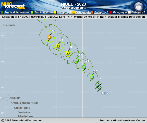
Copy of official data Tropical Storm Nigel Discussion Number 7 NWS National Hurricane Center Miami FL AL152023 1100 PM AST Sat Sep 16 2023 The satellite presentation of the cyclone has improved this evening as there has been an increase in convective banding over the northern portion of the circulation. The center appears to be located near the southern portion of the convective mass. Dvorak Data T-numbers from both SAB and TAFB were T2.5 (35 kt) at 0000 UTC and objective satellite estimates from UW/CIMSS are in the 35 to 40 kt range. Based on these data, the initial intensity has been raised to 35 kt. Nigel becomes the 10th named storm to form in the Atlantic basin since August 20th. Nigel is moving northwestward at about 14 kt. A mid-level ridge to the northeast of the cyclone should steer the storm northwestward during the next few days. After that time, Nigel is expected to turn northward around the western side of the ridge. By the middle of next week, the global model guidance indicates that the storm should turn northeast ahead of a broad mid-latitude trough over the western Atlantic. There is fairly good agreement in the global model guidance on the overall scenario, but there are some timing or forward speed difference later in the period. The NHC forecast track is near the HFIP corrected consensus which is close to a blend of the latest GFS and ECMWF models. Environmental conditions are expected to be conducive for steady intensification during the next few days, with low vertical wind shear and warm sea surface temperatures along the forecast track. A period of rapid intensification is is certainly possible within the next two to three days. Although the SHIP RI probabilities are not very high at the moment, DTOPS gives a 50 percent chance of a 65 kt increase in intensity during the next 72 hours. The NHC forecast is close to that, showing a 60 kt increase in strength during the time. After 72 hours, increasing southwesterly shear is likely to cause gradual weakening. The NHC wind speed forecast is closest to the HFIP corrected consensus. FORECAST POSITIONS AND MAX WINDS INIT 17/0300Z 22.0N 48.0W 35 KT 40 MPH 12H 17/1200Z 23.6N 49.2W 45 KT 50 MPH 24H 18/0000Z 25.3N 50.6W 55 KT 65 MPH 36H 18/1200Z 26.7N 52.2W 65 KT 75 MPH 48H 19/0000Z 27.8N 54.0W 75 KT 85 MPH 60H 19/1200Z 29.4N 55.7W 85 KT 100 MPH 72H 20/0000Z 31.3N 56.7W 95 KT 110 MPH 96H 21/0000Z 36.0N 55.6W 85 KT 100 MPH 120H 22/0000Z 41.9N 47.3W 80 KT 90 MPH $$ Forecaster Brown |