Official Discussion issued by the National Hurricane Center
Nigel (AL152023) DATA RELEASED: 9/21/2023 3:00:00 PM UTC
|
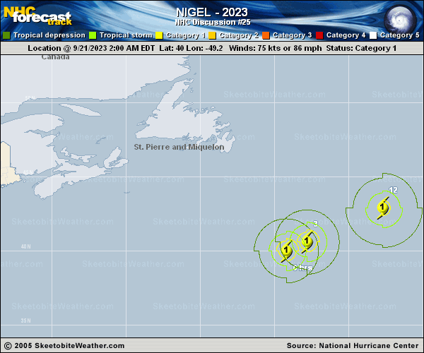
Copy of official data Hurricane Nigel Discussion Number 25 NWS National Hurricane Center Miami FL AL152023 1100 AM AST Thu Sep 21 2023 Nigel is still maintaining some deep convection, with cloud tops in bands to near -70 deg C. However, increasing southwesterly vertical wind shear is beginning to cause an elongation of the cloud pattern toward the northeast. Subjective Dvorak satellite classifications from TAFB and SAB continue to give Current Intensity numbers corresponding to 77 kt, and objective ADT estimates from UW-CIMSS are a little lower than that value. The advisory intensity is held at 75 kt. The current motion is quickly northeastward, or about 050/26 kt. Nigel is embedded in the flow on the southeastern side of a strong deep-layer mid-latitude trough. This steering pattern should continue to carry the cyclone rapidly toward the northeast through tonight. On Friday, Nigel should rotate around the eastern side of a large extratropical cyclone over the North Atlantic. Vertical wind shear over Nigel should become very high within the next 24 hours, and the cyclone will be moving over significantly cooler waters later today. Therefore weakening should occur, and global model guidance indicates that the system will become embedded in a frontal zone by early Friday. In 2 to 3 days, Nigel is expected to merge with the large cyclone over the North Atlantic, and dissipate. FORECAST POSITIONS AND MAX WINDS INIT 21/1500Z 42.2N 45.0W 75 KT 85 MPH 12H 22/0000Z 44.2N 38.8W 65 KT 75 MPH 24H 22/1200Z 47.3N 30.8W 55 KT 65 MPH...POST-TROP/EXTRATROP 36H 23/0000Z 51.0N 24.6W 50 KT 60 MPH...POST-TROP/EXTRATROP 48H 23/1200Z 55.2N 22.9W 50 KT 60 MPH...POST-TROP/EXTRATROP 60H 24/0000Z 57.4N 24.4W 45 KT 50 MPH...POST-TROP/EXTRATROP 72H 24/1200Z...DISSIPATED $$ Forecaster Pasch |