Official Discussion issued by the National Hurricane Center
Nigel (AL152023) DATA RELEASED: 9/21/2023 9:00:00 AM UTC
|
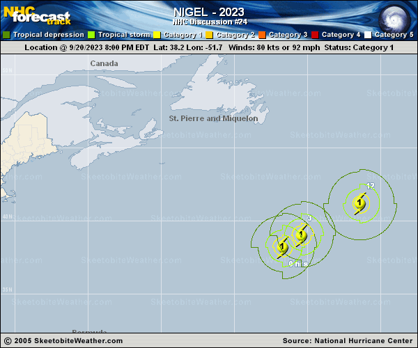
Copy of official data Hurricane Nigel Discussion Number 24 NWS National Hurricane Center Miami FL AL152023 500 AM AST Thu Sep 21 2023 Nigel is starting to feel the effects of increased vertical wind shear this morning. Proxy-vis and infrared satellite imagery show that the large, ragged eye from the past few days has become obscured. An AMSR microwave pass at 0513 UTC confirmed that the eyewall structure has collapsed, and a thick curved band on the northern side is all that remains. Vertical wind shear has the deep convection displaced to the northern side of the system, within the main banding feature, with cold cloud tops in the northwest semicircle near -70 Celsius. Subjective satellite current intensity (CI) values were 4.5 from both TAFB and SAB. Given the degradation in the satellite appearance and these estimates, the initial intensity is set to 75 kt for this advisory. Nigel is moving swiftly to the northeast at an estimated motion of 50/ 26 kt. The system is currently moving within the flow ahead of a mid-latitude trough off the northeast US Coast and Atlantic Canada, with this quick northeast motion expected to continue during the next day or two. Late Friday and into the weekend, models show Nigel interacting with a larger polar low over the North Atlantic. The NHC track forecast is very similar to the previous advisory and remains near the consensus aids. The hurricane is moving into a more hostile environment with vertical deep layer shear forecast to further increase, and sea surface temperatures along the forecast track continue to cool over the northern Atlantic. Nigel is also entering a drier mid-level air mass with relative humidities below 40 percent. Nigel should begin to transition into an extratropical cyclone very soon, and this process is expected to be complete in about 24 hours. The ECMWF and GFS SHIPS guidance show extratropical transition occuring even sooner than what is forecast. The official intensity forecast shows gradual weakening, with Nigel becoming a powerful extratropical cyclone on Friday. By the end of the forecast period, Nigel will become absorbed in the aforementioned larger polar low. FORECAST POSITIONS AND MAX WINDS INIT 21/0900Z 40.6N 47.8W 75 KT 85 MPH 12H 21/1800Z 42.9N 42.7W 70 KT 80 MPH 24H 22/0600Z 45.9N 35.0W 60 KT 70 MPH...POST-TROP/EXTRATROP 36H 22/1800Z 49.5N 27.5W 50 KT 60 MPH...POST-TROP/EXTRATROP 48H 23/0600Z 53.1N 23.6W 50 KT 60 MPH...POST-TROP/EXTRATROP 60H 23/1800Z 56.8N 23.1W 50 KT 60 MPH...POST-TROP/EXTRATROP 72H 24/0600Z 58.3N 24.4W 45 KT 50 MPH...POST-TROP/EXTRATROP 96H 25/0600Z...DISSIPATED $$ Forecaster Kelly |