Official Discussion issued by the National Hurricane Center
Nigel (AL152023) DATA RELEASED: 9/18/2023 9:00:00 PM UTC
|
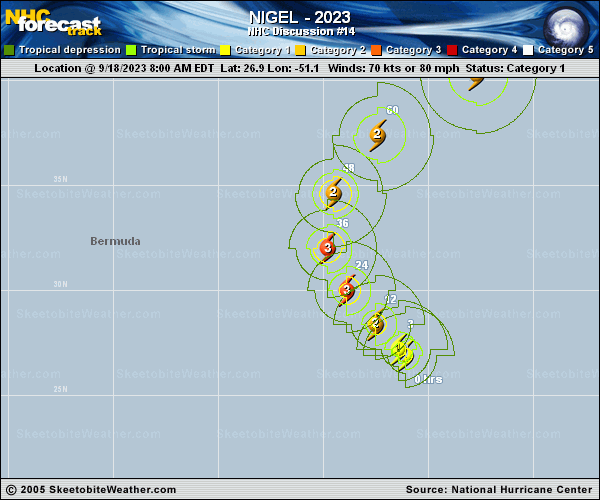
Copy of official data Hurricane Nigel Discussion Number 14 NWS National Hurricane Center Miami FL AL152023 500 PM AST Mon Sep 18 2023 The center of Nigel is embedded within a central dense overcast of cold infrared cloud tops this afternoon. Recent GMI microwave images do not show much improvement to the hurricane's inner core structure, as it appears some drier air could be intruding into the north side of the circulation. There is no eye feature apparent in conventional satellite imagery at this time. The latest subjective Dvorak estimates are T4.0 (SAB) and T4.5 (TAFB). Meanwhile, the latest UW-CIMSS ADT and SATCON intensity estimates are 63 kt and 71 kt, respectively. A blend of these data support holding the initial intensity at 70 kt for this advisory. Despite seemingly conducive environmental conditions for strengthening, Nigel's intensification appears to have been disrupted, possibly by dry air entrainment related to some mid-level shear. If the hurricane can solidify its inner core during the next day or so, the very warm SSTs and relatively low shear should allow for some strengthening in the near term. The NHC forecast has been slightly lowered from the previous one but still shows Nigel peaking near major hurricane intensity in 36-48 h. This prediction lies above the latest intensity guidance, closest to HCCA and some of the regional hurricane models (HAFS-A). Beyond 48 h, increasing deep-layer shear associated with the upper trough and rapidly cooling SSTs are forecast to induce steady weakening through the rest of the period. A mid-level ridge over the central Atlantic continues to steer Nigel northwestward (320/10 kt). The hurricane is expected to turn northward over the next couple of days while it moves around the western periphery of this steering ridge. Then, an upper-level trough moving across the western Atlantic is forecast to cause Nigel to accelerate northeastward and move deeper in the mid-latitudes through late this week. The NHC forecast remains near the center of the tightly clustered track guidance, with a faster forward motion shown later in the period in agreement with the TVCA and HCCA aids. This takes Nigel more quickly into the mid-latitudes, and the latest global model fields and phase diagrams suggest its extratropical transition should be complete by 96 h. FORECAST POSITIONS AND MAX WINDS INIT 18/2100Z 28.0N 52.2W 70 KT 80 MPH 12H 19/0600Z 29.2N 53.3W 80 KT 90 MPH 24H 19/1800Z 31.0N 54.5W 90 KT 105 MPH 36H 20/0600Z 33.4N 54.8W 95 KT 110 MPH 48H 20/1800Z 36.2N 53.5W 95 KT 110 MPH 60H 21/0600Z 39.1N 50.0W 85 KT 100 MPH 72H 21/1800Z 42.1N 43.9W 75 KT 85 MPH 96H 22/1800Z 48.0N 29.0W 60 KT 70 MPH...POST-TROP/EXTRATROP 120H 23/1800Z 56.0N 18.0W 50 KT 60 MPH...POST-TROP/EXTRATROP $$ Forecaster B Reinhart/A Reinhart |