Official Discussion issued by the National Hurricane Center
Nigel (AL152023) DATA RELEASED: 9/17/2023 9:00:00 PM UTC
|
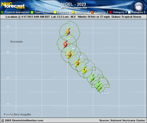
Copy of official data Tropical Storm Nigel Discussion Number 10 NWS National Hurricane Center Miami FL AL152023 500 PM AST Sun Sep 17 2023 Nigel's organization continues to increase, with several convective bands noted over the northern portion of the circulation. Although microwave imagery shows that an eyewall structure has not yet formed, it seems likely that an inner core will develop fairly soon. The current intensity is set at 55 kt based on a subjective Dvorak satellite intensity estimate from TAFB although objective estimates are a little lower. Nigel continues northwestward with an estimated motion of 325/11 kt. The system should continue on a generally northwestward track over the next couple of days while a mid-level high builds to its east-northeast. By Wednesday, Nigel should turn northward and move along the western side of the high. Later in the forecast period, the system is expected to accelerate northeastward in the flow on the southeast side of a strong mid-latitude trough. The NHC forecast is roughly in the middle of the track guidance envelope and lies between the simple and corrected dynamical model consensus solutions. The system's environment appears to be very conducive for strengthening. The vertical wind shear is quite weak and there is well-defined upper-level anticyclonic outflow over the area. The various rapid intensification (RI) indices are in agreement on a significantly higher-than-normal likelihood of RI. This is also reflected in the official intensity forecast, which shows Nigel becoming a major hurricane within the next couple of days. By the end of the forecast period, the system will likely become embedded within a frontal zone and transition into a strong extratropical cyclone. FORECAST POSITIONS AND MAX WINDS INIT 17/2100Z 25.1N 49.5W 55 KT 65 MPH 12H 18/0600Z 26.3N 50.6W 70 KT 80 MPH 24H 18/1800Z 27.8N 52.1W 85 KT 100 MPH 36H 19/0600Z 29.2N 53.6W 100 KT 115 MPH 48H 19/1800Z 31.0N 55.0W 100 KT 115 MPH 60H 20/0600Z 33.1N 55.4W 100 KT 115 MPH 72H 20/1800Z 35.7N 54.2W 90 KT 105 MPH 96H 21/1800Z 41.3N 45.9W 75 KT 85 MPH 120H 22/1800Z 47.8N 31.7W 60 KT 70 MPH...POST-TROP/EXTRATROP $$ Forecaster Pasch |