Official Discussion issued by the National Hurricane Center
Margot (AL142023) DATA RELEASED: 9/9/2023 3:00:00 PM UTC
|
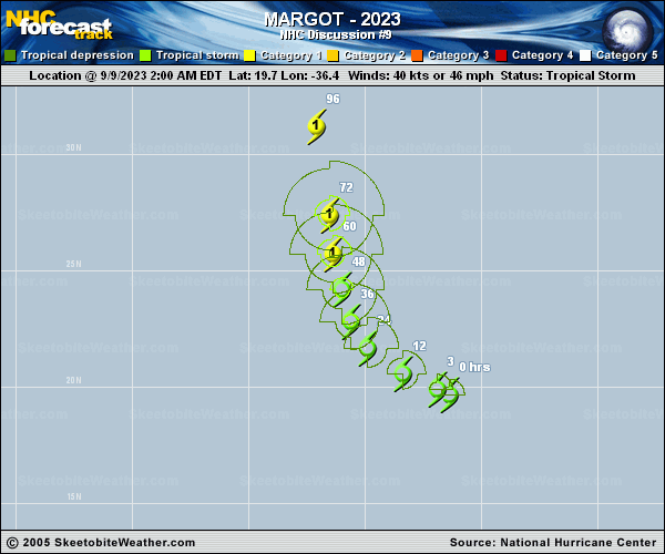
Copy of official data Tropical Storm Margot Discussion Number 9 NWS National Hurricane Center Miami FL AL142023 1100 AM AST Sat Sep 09 2023 Margot is looking a little better organized on satellite imagery this morning compared to yesterday. A SSMIS microwave pass from earlier this morning depicted that some banding features are trying to develop on the northeastern side of the low-level center. The deep convection also continues to burst near the center of the system as well, with cold cloud tops. Subjective and objective satellite intensity estimates from SAB/TAFB remain the same as the previous cycle. Therefore, the initial intensity remains 40 kt for this advisory. Margot is currently within an environment of moderate vertical wind shear and dry mid-level relative humidities. However, despite the less than favorable environment the intensity guidance indicates that Margot will gradually strengthen over the next few days as it enters a more favorable upper-level wind pattern, and continues over warm sea surface temperatures. The NHC forecast therefore shows slow strengthening throughout the forecast period, similar to the previous advisory, and lies near the HCCA and IVCN consensus aids. Margot is moving west-northwestward at 10 kt around the edge of a subtropical ridge over the eastern Atlantic. This west-northwest motion will continue during the next day or so, followed by a turn to the northwest and northward by late in the weekend and early next week, with a slower forward motion. Models are in fairly good agreement in the short-term. However, the track model spread increases in both cross- and along-track spread beyond day 3 to 4, as there is some uncertainty in the steering flow. The NHC track forecast lies near the model consensus aids, and only slight adjustments to the previous forecast were made. FORECAST POSITIONS AND MAX WINDS INIT 09/1500Z 20.5N 38.0W 40 KT 45 MPH 12H 10/0000Z 21.2N 39.3W 45 KT 50 MPH 24H 10/1200Z 22.3N 40.3W 50 KT 60 MPH 36H 11/0000Z 23.6N 40.8W 55 KT 65 MPH 48H 11/1200Z 25.0N 41.4W 60 KT 70 MPH 60H 12/0000Z 26.6N 41.7W 65 KT 75 MPH 72H 12/1200Z 28.4N 41.9W 70 KT 80 MPH 96H 13/1200Z 32.0N 42.4W 75 KT 85 MPH 120H 14/1200Z 34.3N 43.2W 75 KT 85 MPH $$ Forecaster Kelly |