Official Discussion issued by the National Hurricane Center
Margot (AL142023) DATA RELEASED: 9/9/2023 9:00:00 AM UTC
|
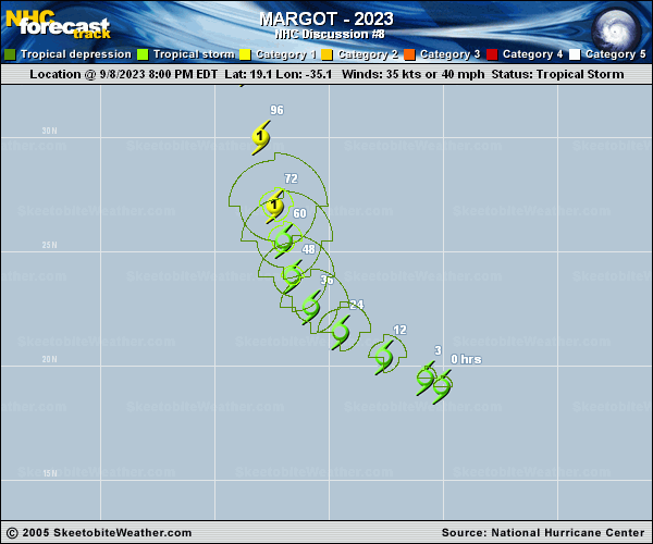
Copy of official data Tropical Storm Margot Discussion Number 8 NWS National Hurricane Center Miami FL AL142023 500 AM AST Sat Sep 09 2023 Margot has become better organized this morning. The earlier noted exposed surface center has become obscured with bursts of deep convection while the outflow pattern has become more diffluent in the northeast quadrant of the cyclone. Therefore, the initial intensity is raised to 40 kt and is based on the TAFB and SAB Dvorak satellite intensity estimates. Although some northerly shear and dry mid-level air intruding from the southwest has slowed the intensification rate, the intensity guidance indicates that Margot will become a hurricane next week. In fact, the upper-level pattern becomes more favorable by mid-period, although the statistical SHIPS intensity guidance shows modest southerly shear at the time. Therefore, the official forecast indicates gradual intensification through the entire forecast period. The NHC intensity forecast favors the reliable multi-model consensus aids, which is just below the Decay SHIPS beyond day 3. Margot is moving west-northwestward at 11 kt around the southwestern periphery of a subtropical high over the eastern Atlantic. A west-northwest to northwest motion is forecast through early Sunday, followed by a turn toward north-northwest to north by late Sunday with some reduction in forward speed. A slight adjustment to the right of the previous forecast track was made to hedge closer to the HFIP HCCA corrected consensus aid and TVCA simple multi-model guidance. FORECAST POSITIONS AND MAX WINDS INIT 09/0900Z 19.9N 36.9W 40 KT 45 MPH 12H 09/1800Z 20.6N 38.4W 45 KT 50 MPH 24H 10/0600Z 21.7N 39.9W 45 KT 50 MPH 36H 10/1800Z 22.8N 40.6W 55 KT 65 MPH 48H 11/0600Z 24.2N 41.0W 60 KT 70 MPH 60H 11/1800Z 25.7N 41.4W 65 KT 75 MPH 72H 12/0600Z 27.4N 41.5W 70 KT 80 MPH 96H 13/0600Z 31.2N 42.1W 75 KT 85 MPH 120H 14/0600Z 34.5N 43.4W 75 KT 85 MPH $$ Forecaster Roberts |