Official Discussion issued by the National Hurricane Center
Margot (AL142023) DATA RELEASED: 9/17/2023 9:00:00 AM UTC
|
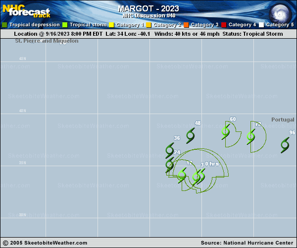
Copy of official data Tropical Storm Margot Discussion Number 40 NWS National Hurricane Center Miami FL AL142023 900 AM GMT Sun Sep 17 2023 There haven't been a lot of changes with Margot overnight, with no associated deep convection and an exposed low-level center. The initial wind speed is lowered to 35 kt in accordance with the latest Dvorak estimates. Very dry mid-level air and upper-level convergence will likely prevent any re-development of convection, so the storm is now forecast to become post-tropical later today. No significant changes were made to the intensity forecast, with a slight increase in winds possible as Margot interacts with an upper-level trough in a couple of days, but not as a tropical cyclone. Margot is moving westward at about 8 kt. It should turn northward within 24 hours and then eastward or east-southeastward as it moves around the subtropical ridge, finally dissipating in the hostile environment. The new NHC track forecast is essentially an update of the previous one, near or just south of the model consensus. FORECAST POSITIONS AND MAX WINDS INIT 17/0900Z 34.0N 41.4W 35 KT 40 MPH 12H 17/1800Z 34.5N 42.7W 30 KT 35 MPH...POST-TROP/REMNT LOW 24H 18/0600Z 35.8N 43.4W 30 KT 35 MPH...POST-TROP/REMNT LOW 36H 18/1800Z 37.4N 42.3W 30 KT 35 MPH...POST-TROP/REMNT LOW 48H 19/0600Z 38.2N 39.2W 35 KT 40 MPH...POST-TROPICAL 60H 19/1800Z 38.0N 35.8W 35 KT 40 MPH...POST-TROPICAL 72H 20/0600Z 37.0N 33.5W 30 KT 35 MPH...POST-TROP/REMNT LOW 96H 21/0600Z 36.5N 31.0W 25 KT 30 MPH...POST-TROP/REMNT LOW 120H 22/0600Z...DISSIPATED $$ Forecaster Blake |