Official Discussion issued by the National Hurricane Center
Margot (AL142023) DATA RELEASED: 9/15/2023 9:00:00 PM UTC
|
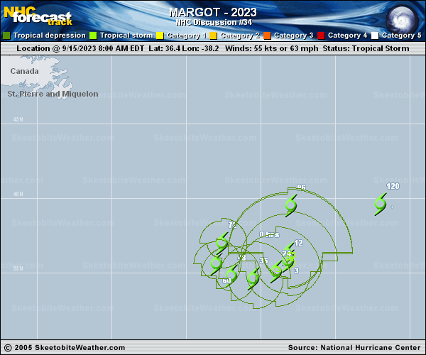
Copy of official data Tropical Storm Margot Discussion Number 34 NWS National Hurricane Center Miami FL AL142023 900 PM GMT Fri Sep 15 2023 Margot has changed little in appearance since the last advisory. Visible imagery still shows a broad and robust low-level circulation with occasional bursts of convection near the center. A couple microwave passes over the past few hours showed some fragmented curved bands in the northeast quadrant. Given little change in appearance, the initial intensity is held at 55 kt, closest to the TAFB Dvorak estimate. The tropical storm is still drifting southeastward at 4 kt. Margot is on the southeast side of a building mid-level ridge and expected to complete a clockwise turn by Sunday. Early next week, the storm should begin a northward motion followed by a turn to the east. By days 4 and 5 there is more uncertainty in the track forecast. The model guidance has shifted south and trended slower than the previous NHC track forecast. The biggest changes in the track forecast for this advisory show a noticeable shift to the south and a decrease in forward motion late in the forecast period. Environmental conditions are relatively hostile and should cause a continued weakening trend. Still, marginal sea surface temperatures could lead to periodic flares of convection. Therefore, the latest NHC intensity forecast shows a gradual weakening associated with the expected spin down. Margot is still expected to become a post-tropical cyclone by day 5. FORECAST POSITIONS AND MAX WINDS INIT 15/2100Z 36.0N 37.9W 55 KT 65 MPH 12H 16/0600Z 35.5N 38.1W 50 KT 60 MPH 24H 16/1800Z 34.8N 39.5W 45 KT 50 MPH 36H 17/0600Z 34.6N 41.0W 45 KT 50 MPH 48H 17/1800Z 35.2N 42.4W 40 KT 45 MPH 60H 18/0600Z 36.2N 42.7W 40 KT 45 MPH 72H 18/1800Z 37.9N 41.4W 40 KT 45 MPH 96H 19/1800Z 39.2N 36.0W 40 KT 45 MPH 120H 20/1800Z 39.0N 31.2W 35 KT 40 MPH...POST-TROP/EXTRATROP $$ Forecaster Bucci |