Official Discussion issued by the National Hurricane Center
Margot (AL142023) DATA RELEASED: 9/14/2023 9:00:00 PM UTC
|
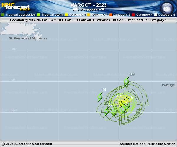
Copy of official data Hurricane Margot Discussion Number 30 NWS National Hurricane Center Miami FL AL142023 Issued by the NWS Weather Prediction Center College Park MD 900 PM GMT Thu Sep 14 2023 An inner eyewall redeveloped today, with the outer eyewall persisting. Outflow is well-established to Margot's north and northeast, near the base of a shortwave trough in the northeast Atlantic. Vertical wind shear over the hurricane appears modest and not enough to cause additional weakening. The initial wind speed remains set to 70 kt, a compromise between the earlier higher SAR estimates and Dvorak values closer to 65 kt, as Margot does not appear to have degraded today. Margot has turned further to the right, or 050/4. A blocking ridge over the north-central Atlantic should force Margot to slow down and execute a clockwise loop during the next few days. After the ridge shifts eastward, the hurricane should gain some latitude and begin to move more to the northeast at the end of the forecast period. Model guidance is in good agreement on this general idea, although there is considerable spread at long range with the GFS faster and more to the northeast than the ECMWF-based guidance. The new forecast remains close to continuity, near or just behind the model consensus. The hurricane should gradually weaken as the large system slows down and upwells cooler water, along with it crossing over its own cold wake. Simulated satellite imagery indicates that over the weekend, Margot could be struggling to maintain convection near its center. There is plenty of mid-level dry air in the surrounding environment, as it navigates around the center of a warm-core high, which could be mixed in the core. Margot could become a post-tropical cyclone without deep convection early next week, but that really depends on how it handles the more hostile conditions and if it can regain convection as it tries to escape into the westerlies. Given how resilient this season's tropical cyclones have been, it could be optimistic that Margot is post-tropical on day 5. FORECAST POSITIONS AND MAX WINDS INIT 14/2100Z 36.9N 39.3W 70 KT 80 MPH 12H 15/0600Z 36.9N 38.9W 65 KT 75 MPH 24H 15/1800Z 36.4N 38.8W 65 KT 75 MPH 36H 16/0600Z 35.8N 39.2W 60 KT 70 MPH 48H 16/1800Z 35.4N 40.4W 50 KT 60 MPH 60H 17/0600Z 35.4N 41.8W 45 KT 50 MPH 72H 17/1800Z 35.7N 43.3W 45 KT 50 MPH 96H 18/1800Z 38.6N 42.6W 50 KT 60 MPH 120H 19/1800Z 40.2N 37.9W 45 KT 50 MPH...POST-TROP/EXTRATROP $$ Forecaster Roth/Blake |