Official Discussion issued by the National Hurricane Center
Margot (AL142023) DATA RELEASED: 9/12/2023 9:00:00 AM UTC
|
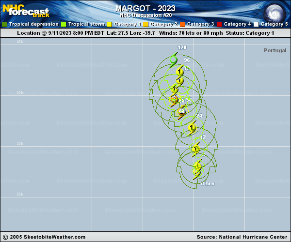
Copy of official data Hurricane Margot Discussion Number 20 NWS National Hurricane Center Miami FL AL142023 900 AM GMT Tue Sep 12 2023 Margot's eye became obscured in infrared satellite imagery a couple of hours ago, but the hurricane still has a well-defined Central Dense Overcast surrounded by convective banding features. A dry slot has become entrained into the eastern part of the circulation, between the CDO and the outermost banding. Based on consensus Dvorak estimates of T4.5 from TAFB and SAB, the initial intensity is raised to 75 kt. Margot is moving northward (360/11 kt) along the western periphery of a mid-level ridge emanating out of western Africa, and this steering mechanism should keep the hurricane on a general northward or north-northwestward trajectory for the next few days. A blocking ridge is forecast to form in 2-3 days over the north Atlantic, which is likely to cause Margot to slow down during the middle to latter part of the forecast period. However, the ridge may be relatively progressive, and by day 5 many of the track models show the storm picking up some speed again once the ridge gets out of the way. The most notable change in the NHC track forecast is that it's faster than the previous prediction on days 4 and 5 to better align with the latest guidance. The hurricane is currently within a strongly diffluent environment to the east of an upper-level trough, but the environment is forecast to evolve to an anticyclone aloft and low shear within the next 12 hours. Continued strengthening is therefore likely, but any intensification trend could be halted soon after 24 hours when the hurricane slows down and potentially upwells cooler waters. The NHC intensity forecast is above the intensity consensus during the first day or two and is closest to the statistical-dynamical guidance. Weakening is likely to occur after 48 hours due to cooler waters and an increase in deep-layer shear. FORECAST POSITIONS AND MAX WINDS INIT 12/0900Z 29.3N 39.5W 75 KT 85 MPH 12H 12/1800Z 30.9N 39.9W 80 KT 90 MPH 24H 13/0600Z 32.7N 40.8W 85 KT 100 MPH 36H 13/1800Z 34.0N 41.7W 85 KT 100 MPH 48H 14/0600Z 35.0N 42.1W 85 KT 100 MPH 60H 14/1800Z 36.0N 41.9W 80 KT 90 MPH 72H 15/0600Z 36.9N 41.6W 75 KT 85 MPH 96H 16/0600Z 38.2N 42.6W 60 KT 70 MPH 120H 17/0600Z 40.4N 43.4W 50 KT 60 MPH $$ Forecaster Berg |