Official Discussion issued by the National Hurricane Center
Margot (AL142023) DATA RELEASED: 9/10/2023 9:00:00 AM UTC
|
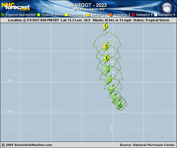
Copy of official data Tropical Storm Margot Discussion Number 12 NWS National Hurricane Center Miami FL AL142023 500 AM AST Sun Sep 10 2023 Westerly shear and a slug of dry air, which was noted in the MET-10 water vapor imagery, impedes Margot's ability to sustain deep convection near the surface center while most convection remains displaced to the northeast. A recent AMSR2 microwave pass confirmed that the surface center has again become exposed to the southwest of the convective canopy. The initial intensity is held at 45 kt and is based on the TAFB and SAB Dvorak satellite intensity estimates. The aforementioned moderate shear should continue to undercut the diffluent southerly flow aloft during the next couple of days. Afterward, the statistical-dynamic SHIPS guidance indicates that Margot will slip under a narrow upper-level ridge, favoring intensification. The only inhibiting factor during the latter part of the forecast appears to be a less conducive surrounding thermodynamic environment, which should affect the intensity rate some. Therefore, only gradual strengthening is forecast and agrees with intensity consensus models but below the HAFS-B hurricane model, which predicts Margot as a hurricane on day 4. For now, the official forecast shows Margot becoming a hurricane in 48 hours in agreement with the reliable intensity consensus aids, but this predicted rate of intensification could be generous. Through the early part of this week, Margot is expected to turn north-northwestward to northward while entering a growing weakness in the central Atlantic subtropical ridge. Beyond day 3, Margot will likely slow its forward motion in response to a building or blocking high to the northwest. There remains quite a bit of model spread/uncertainty late in the period, with the two global model clusters showing Margot either turning eastward or moving toward the northwest to west. The NHC track forecast conservatively lies between the HFIP HCCA and simple consensus TVCA, which splits the two model cluster solutions. FORECAST POSITIONS AND MAX WINDS INIT 10/0900Z 22.1N 39.6W 45 KT 50 MPH 12H 10/1800Z 23.1N 40.1W 50 KT 60 MPH 24H 11/0600Z 24.8N 40.5W 55 KT 65 MPH 36H 11/1800Z 26.5N 40.7W 60 KT 70 MPH 48H 12/0600Z 28.2N 40.8W 65 KT 75 MPH 60H 12/1800Z 30.1N 40.9W 70 KT 80 MPH 72H 13/0600Z 32.4N 41.0W 70 KT 80 MPH 96H 14/0600Z 35.0N 41.6W 75 KT 85 MPH 120H 15/0600Z 36.7N 41.9W 75 KT 85 MPH $$ Forecaster Roberts |