Official Discussion issued by the National Hurricane Center
Margot (AL142023) DATA RELEASED: 9/9/2023 9:00:00 PM UTC
|
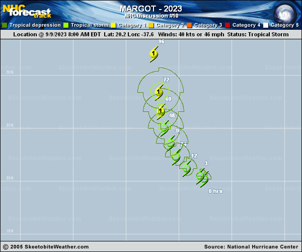
Copy of official data Tropical Storm Margot Discussion Number 10 NWS National Hurricane Center Miami FL AL142023 500 PM AST Sat Sep 09 2023 Margot's satellite depiction has not improved much throughout the afternoon. The system is dealing with west-southwesterly wind shear, and struggling to become better organized. The low-level center does have intermittent convective bursts that are then sheared to the northeast. Given the lack of improvement in satellite, the subjective and objective satellite intensity estimates from SAB/TAFB remain steady. Therefore, the initial intensity remains 40 kt for this advisory. Environmental conditions are currently not very favorable with moderate vertical wind shear, and dry mid-levels. Despite the less than favorable environment the intensity guidance indicates that Margot will gradually strengthen over the next few days as it enters a more conducive upper-level wind pattern. The NHC forecast is similar to the previous one, with gradual strengthening anticipated, and lies near the corrected consensus aids. Margot is moving northwestward at 8 kt around the edge of a subtropical ridge over the eastern Atlantic. This northwest motion will continue during the next day or so, followed by a turn to the north-northwest and north by late in the weekend and early next week. Models are in fairly good agreement in the short-term. However, the track model spread increases in both cross- and along-track directions beyond day 3. There has been a shift to the right in the consensus aids, and the NHC has followed suit with a slight shift to the right in the extended range. However, the NHC track forecast remains to the left of some of the consensus aids, and if this trend continues further adjustments to the forecast track will be needed. FORECAST POSITIONS AND MAX WINDS INIT 09/2100Z 21.0N 38.7W 40 KT 45 MPH 12H 10/0600Z 21.7N 39.7W 45 KT 50 MPH 24H 10/1800Z 23.1N 40.3W 50 KT 60 MPH 36H 11/0600Z 24.6N 40.7W 50 KT 60 MPH 48H 11/1800Z 26.0N 41.0W 55 KT 65 MPH 60H 12/0600Z 27.7N 41.2W 60 KT 70 MPH 72H 12/1800Z 29.7N 41.3W 65 KT 75 MPH 96H 13/1800Z 33.1N 41.8W 70 KT 80 MPH 120H 14/1800Z 34.8N 41.8W 75 KT 85 MPH $$ Forecaster Kelly |