Official Discussion issued by the National Hurricane Center
Katia (AL122023) DATA RELEASED: 9/4/2023 9:00:00 AM UTC
|
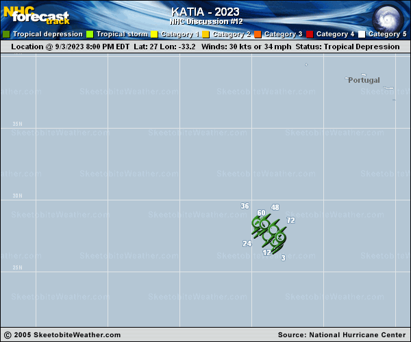
Copy of official data Tropical Depression Katia Discussion Number 12 NWS National Hurricane Center Miami FL AL122023 900 AM GMT Mon Sep 04 2023 Katia barely qualifies as a tropical cyclone at this time. The system is producing a few puffs of deep convection over the northern portion of its circulation. Earlier scatterometer data indicated that the cyclone had weakened to a tropical depression and the current intensity estimate is kept at 30 kt. This is in good agreement with various objective estimates from UW-CIMSS. The depression is moving northwestward, or at about 310/6 kt. Katia's northwestward progress will soon be blocked by a high pressure area ahead of it. Then, the flow on the southwestern side of a large cyclone over the eastern Atlantic is likely to cause the system to make a U-Turn and move slowly southeastward to south-southeastward in 24 to 72 hours. The official forecast is a blend of the GFS and ECMWF solutions and is similar to the previous NHC track. Katia should remain in an environment of very dry low- to mid-level air with moderate vertical shear. Therefore, the cyclone is likely to degenerate into a remnant low by tonight, and dissipate in a few days. This is also consistent with various global model predictions. FORECAST POSITIONS AND MAX WINDS INIT 04/0900Z 27.7N 33.7W 30 KT 35 MPH 12H 04/1800Z 28.0N 34.3W 30 KT 35 MPH 24H 05/0600Z 28.4N 34.6W 25 KT 30 MPH...POST-TROP/REMNT LOW 36H 05/1800Z 28.5N 34.4W 25 KT 30 MPH...POST-TROP/REMNT LOW 48H 06/0600Z 28.2N 33.9W 20 KT 25 MPH...POST-TROP/REMNT LOW 60H 06/1800Z 27.7N 33.5W 20 KT 25 MPH...POST-TROP/REMNT LOW 72H 07/0600Z 26.7N 33.1W 20 KT 25 MPH...POST-TROP/REMNT LOW 96H 08/0600Z...DISSIPATED $$ Forecaster Pasch |