Official Discussion issued by the National Hurricane Center
Katia (AL122023) DATA RELEASED: 9/4/2023 3:00:00 AM UTC
|
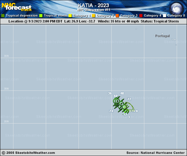
Copy of official data Tropical Depression Katia Discussion Number 11 NWS National Hurricane Center Miami FL AL122023 300 AM GMT Mon Sep 04 2023 Deep convection has been on the decline and only a small area of thunderstorms remain well north of the center. A recent ASCAT pass showed peak winds in the 25-30 kt range, and based on that data, Katia has been downgraded to a 30-kt tropical depression. This value is also in line with the latest satellite intensity estimates. The depression is moving slowly west-northwestward. A slow west-northwestward to northwestward motion is expected for about another day before the system reverses course and drifts southeastward in the flow between a low- to mid-level ridge to its west and a deep-layer low to the northeast. Only small changes were made to the previous NHC track forecast, and this one lies near the various consensus models. West-southwesterly vertical wind shear and dry air should continue to weaken Katia, and this system will likely become a remnant low in 12 to 24 hours. Dissipation is expected in 3 to 4 days. FORECAST POSITIONS AND MAX WINDS INIT 04/0300Z 27.1N 33.4W 30 KT 35 MPH 12H 04/1200Z 27.5N 33.9W 30 KT 35 MPH 24H 05/0000Z 28.1N 34.5W 25 KT 30 MPH...POST-TROP/REMNT LOW 36H 05/1200Z 28.4N 34.6W 25 KT 30 MPH...POST-TROP/REMNT LOW 48H 06/0000Z 28.3N 34.1W 25 KT 30 MPH...POST-TROP/REMNT LOW 60H 06/1200Z 27.9N 33.5W 20 KT 25 MPH...POST-TROP/REMNT LOW 72H 07/0000Z 27.4N 33.0W 20 KT 25 MPH...POST-TROP/REMNT LOW 96H 08/0000Z...DISSIPATED $$ Forecaster Cangialosi |