Official Discussion issued by the National Hurricane Center
Jose (AL112023) DATA RELEASED: 8/31/2023 3:00:00 PM UTC
|
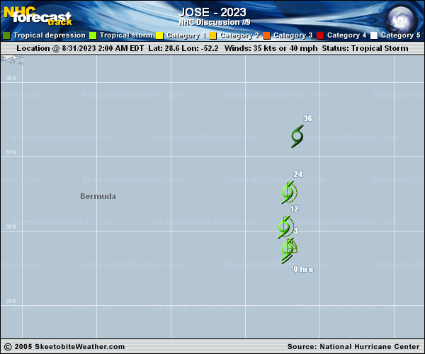
Copy of official data Tropical Storm Jose Discussion Number 9 NWS National Hurricane Center Miami FL AL112023 1100 AM AST Thu Aug 31 2023 Jose is producing bursts of deep convection near and over the estimated center position this morning. Overnight microwave data suggest the surface center was pulled slightly eastward by an increase in convection during the diurnal maximum period. The various satellite intensity estimates range from 32-45 kt this morning, with the subjective Dvorak classifications from SAB and TAFB (45 kt) higher than the objective UW-CIMSS estimates which are around 35 kt. A timely ASCAT-B pass over Jose shows believable wind vectors up to 32 kt in the eastern semicircle, which supports holding the initial intensity at 35 kt for this advisory. The storm is moving northward at about 6 kt. An acceleration toward the north is expected during the next day or so as the small system gets caught in the broader cyclonic circulation associated with Hurricane Franklin. Deep-layer shear is forecast to increase over Jose as it accelerates northward toward Franklin, but Jose appears likely to maintain some tropical-storm-force winds in its eastern semicircle due to its faster northward motion. There have been no notable changes to the NHC track or intensity forecast, and Jose is now expected to be absorbed by Franklin in 36 h, in agreement with the latest global models. FORECAST POSITIONS AND MAX WINDS INIT 31/1500Z 29.7N 52.1W 35 KT 40 MPH 12H 01/0000Z 31.4N 52.0W 35 KT 40 MPH 24H 01/1200Z 34.4N 51.7W 35 KT 40 MPH 36H 02/0000Z...DISSIPATED $$ Forecaster Reinhart |