Official Discussion issued by the National Hurricane Center
Eleven (AL112023) DATA RELEASED: 8/30/2023 9:00:00 PM UTC
|
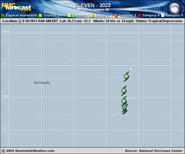
Copy of official data Tropical Depression Eleven Discussion Number 6 NWS National Hurricane Center Miami FL AL112023 500 PM AST Wed Aug 30 2023 The depression has become a little less organized on visible satellite imagery this afternoon, with multiple vortices exposed on the western edge of the convection. Satellite intensity estimates from TAFB/SAB are around 30 kt, and given the current disorganized structure, with an exposed center, the intensity will remain at 30 kt for this advisory. The depression continues to drift over the central Atlantic. It will slowly move northward later today, and then a little faster northward by Thursday. The NHC track forecast is close to the previous one, and lies near the corrected consensus aids. The intensity forecast remains unchanged from the previous forecast. The depression still may briefly strengthen into a very short-lived tropical storm, but most of the intensity guidance keeps the system as a depression. As the system moves northward, it will encounter dry air and increased vertical wind shear. Therefore, the depression is forecast to become a post-tropical remnant low in about day or so, and dissipate by 48 h. FORECAST POSITIONS AND MAX WINDS INIT 30/2100Z 28.5N 52.3W 30 KT 35 MPH 12H 31/0600Z 29.0N 52.4W 30 KT 35 MPH 24H 31/1800Z 30.4N 52.4W 30 KT 35 MPH 36H 01/0600Z 32.7N 52.0W 30 KT 35 MPH...POST-TROP/REMNT LOW 48H 01/1800Z...DISSIPATED $$ Forecaster Kelly/Cangialosi |