Official Discussion issued by the National Hurricane Center
Eleven (AL112023) DATA RELEASED: 8/29/2023 9:00:00 PM UTC
|
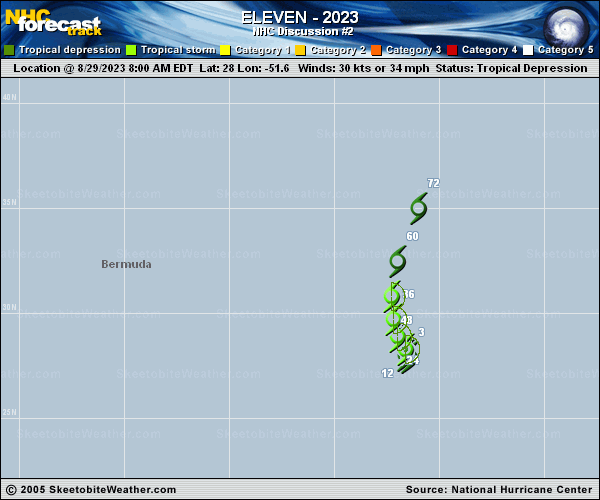
Copy of official data Tropical Depression Eleven Discussion Number 2 NWS National Hurricane Center Miami FL AL112023 500 PM AST Tue Aug 29 2023 The center of the depression is exposed this afternoon. Its associated convection remains displaced over the eastern portion of the circulation by westerly shear. Since the satellite presentation has not improved since the earlier ASCAT retrievals, the initial intensity remains 30 kt for this advisory. Visible and microwave images indicate the depression has moved little since this morning, and it appears to be currently drifting north-northwestward at 345/2 kt within weak steering currents. A ridge to the north of the depression is forecast to slide eastward through midweek, which should allow the cyclone to gradually turn northward and north-northeastward as it accelerates within deepening southerly flow ahead of Hurricane Franklin. The updated NHC track forecast has been adjusted slightly westward in agreement within the latest multi-model consensus aids. There is a brief window during the next day or so where the models suggest the shear could decrease enough to allow the depression to strengthen into a tropical storm. Afterwards, upper-level outflow from Franklin will likely strip away its convection and inhibit any further intensification. The depression is forecast to become post-tropical shortly before it becomes absorbed in about 72 h by the broader circulation associated with Franklin. FORECAST POSITIONS AND MAX WINDS INIT 29/2100Z 28.2N 51.8W 30 KT 35 MPH 12H 30/0600Z 28.6N 52.1W 30 KT 35 MPH 24H 30/1800Z 29.4N 52.5W 35 KT 40 MPH 36H 31/0600Z 30.4N 52.6W 35 KT 40 MPH 48H 31/1800Z 32.0N 52.4W 30 KT 35 MPH 60H 01/0600Z 34.0N 51.6W 30 KT 35 MPH...POST-TROP/REMNT LOW 72H 01/1800Z...DISSIPATED $$ Forecaster Reinhart |