Official Discussion issued by the National Hurricane Center
Idalia (AL102023) DATA RELEASED: 8/31/2023 3:00:00 PM UTC
|
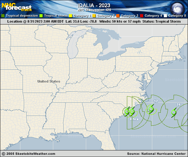
Copy of official data Tropical Storm Idalia Discussion Number 20 NWS National Hurricane Center Miami FL AL102023 1100 AM EDT Thu Aug 31 2023 Satellite imagery, surface observations, and Air Force Reserve Hurricane Hunter data all indicate that Idalia continues to tangle with a frontal boundary that extends northward offshore the Outer Banks. In addition, organized deep convection has mostly dissipated near the center, and it appears that Idalia is on its way to becoming extratropical. The initial intensity remains 50 kt based on coastal wind reports and the reconnaissance data. Global model fields show winds increasing on the northwestern side of the frontal boundary during the day as Idalia is pulling away from the coast of North Carolina, and as a result, the NHC intensity forecast shows some strengthening in the short term. Idalia is expected to become fully extratropical by this evening, which is now shown in the official forecast. Winds should begin decreasing tonight, and simulated satellite imagery from the GFS and ECMWF models suggests that the circulation will continue to be devoid of deep convection, and attached to a front, through at least 36 hours. By 48 hours, the low will reach warmer waters, the front is likely to weaken, and the ECMWF shows deep convection redeveloping. As a result, the official forecast shows Idalia becoming a tropical storm again on Saturday. Intensity-wise, the guidance indicates that the peak winds are likely to fluctuate between 40-45 kt from days 2 through 5. Idalia is now moving eastward, or 090/17 kt, between a deep-layer trough over the northeastern U.S. and a subtropical anticyclone near the Bahamas. The trough is likely to bypass Idalia in a few days, which will cause its eastward motion to slow down to about 5 kt on days 2 and 3 as it approaches Bermuda. On days 4 and 5, a second trough is expected to turn Idalia to the northeast, but still at a relatively slow forward speed. The track guidance is in a bit more agreement than the past few days, and the NHC forecast lies between the TVCX and HCCA consensus aids. KEY MESSAGES: 1. Rainfall will be diminishing by early afternoon from coastal North Carolina into far southeast Virginia. Moderate river flooding, with considerable impacts, will continue across coastal North Carolina through today. 2. Coastal flooding is expected within the Storm Surge Watch area in North Carolina today. Residents in these areas should follow any advice given by local officials. 3. Tropical storm conditions will continue across eastern North Carolina within the Tropical Storm Warning area through this evening. FORECAST POSITIONS AND MAX WINDS INIT 31/1500Z 33.6N 75.8W 50 KT 60 MPH 12H 01/0000Z 33.6N 73.2W 55 KT 65 MPH...POST-TROP/EXTRATROP 24H 01/1200Z 32.8N 70.1W 45 KT 50 MPH...POST-TROP/EXTRATROP 36H 02/0000Z 31.7N 68.1W 40 KT 45 MPH...POST-TROP/EXTRATROP 48H 02/1200Z 31.1N 67.3W 40 KT 45 MPH...TROPICAL CYCLONE 60H 03/0000Z 31.1N 66.6W 40 KT 45 MPH 72H 03/1200Z 31.8N 65.3W 45 KT 50 MPH 96H 04/1200Z 34.3N 62.0W 45 KT 50 MPH 120H 05/1200Z 37.0N 61.0W 45 KT 50 MPH $$ Forecaster Berg |