Official Discussion issued by the National Hurricane Center
Ten (AL102023) DATA RELEASED: 8/26/2023 10:00:00 PM UTC
|
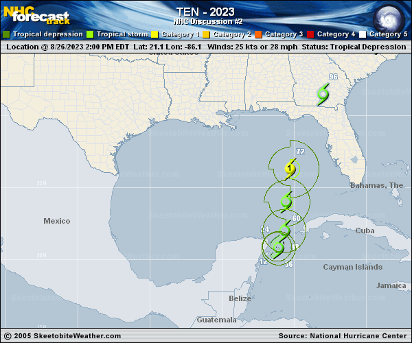
Copy of official data Tropical Depression Ten Discussion Number 2 NWS National Hurricane Center Miami FL AL102023 1000 PM CDT Sat Aug 26 2023 Images from the Mexico meteorological service's radar in Cancun show that the depression has a small but well-defined circulation with spiral banding extending no more than about 60 n mi from the center. This feature is embedded within a larger circulation with scattered deep convection covering the northwestern Caribbean Sea, extreme southeastern Gulf of Mexico, and adjacent land areas. The initial intensity is set to 30 kt based on the latest subjective Dvorak estimate from TAFB and objective numbers from UW-CIMSS. The depression appears to be drifting toward the southwest with an initial motion of 230/2 kt, with low- to mid-level ridging located to its north and northwest. The system is expected to continue meandering over the northwestern Caribbean Sea for the next 24-36 hours. After that time, a developing trough over the Gulf of Mexico and strengthening ridging over the western Atlantic is expected to begin lifting the system toward the north and north-northeast over the eastern Gulf of Mexico toward Florida, and then near the southeastern coast of the U.S. The updated NHC track forecast lies on top of or very near the previous prediction and closely follows the TVCX and HCCA consensus aids. Assuming the depression's center does not move over the Yucatan Peninsula, very warm waters and low to moderate vertical shear should support gradual strengthening during the next few days. The NHC intensity prediction is a little below the consensus aids during the first 36 hours of the forecast but then converges with those aids thereafter, showing the system reaching hurricane strength by 60 hours. The system is expected to remain a hurricane, and potentially continue strengthening, up until it reaches the Gulf coast of Florida on Wednesday. Users are reminded to continue monitoring forecasts for any changes to the system's expected intensity as it approaches Florida. Land interaction and increasing shear should lead to fast weakening after the system moves over land, but it could still produce tropical-storm-force winds near and offshore the southeastern coast of the U.S. even if the center is inland. KEY MESSAGES: 1. Heavy rainfall from Tropical Depression Ten is expected across the eastern Yucatan Peninsula and western Cuba. The heavy rainfall may produce areas of flash and urban flooding, as well as landslides, across western Cuba. The depression is forecast to become a tropical storm by Sunday, and tropical storm conditions are expected over portions of the Yucatan Peninsula and extreme western Cuba where a Tropical Storm Warning is in effect. Tropical storm conditions are possible on the Isle of Youth, where a Tropical Storm Watch is in effect. 2. The depression is forecast to strengthen during the next few days and could become a hurricane over the eastern Gulf of Mexico, bringing a potential of dangerous storm surge, heavy rainfall, and strong winds to portions of the west coast of Florida and the Florida Panhandle by the middle of next week. Heavy rainfall is also likely to spread into portions of the Southeast U.S. by mid to late next week. Although it is too soon to specify the exact location and magnitude of these impacts, residents in these areas should monitor updates to the forecast of this system and ensure that they have their hurricane plan in place. FORECAST POSITIONS AND MAX WINDS INIT 27/0300Z 21.1N 86.4W 30 KT 35 MPH 12H 27/1200Z 20.9N 86.4W 35 KT 40 MPH 24H 28/0000Z 20.9N 86.2W 40 KT 45 MPH 36H 28/1200Z 21.6N 85.9W 45 KT 50 MPH 48H 29/0000Z 23.1N 85.7W 55 KT 65 MPH 60H 29/1200Z 25.0N 85.5W 65 KT 75 MPH 72H 30/0000Z 27.5N 84.8W 70 KT 80 MPH 96H 31/0000Z 32.7N 81.5W 45 KT 50 MPH...INLAND 120H 01/0000Z 35.2N 76.7W 35 KT 40 MPH...INLAND $$ Forecaster Berg |