Official Discussion issued by the National Hurricane Center
Idalia (AL102023) DATA RELEASED: 8/29/2023 9:00:00 PM UTC
|
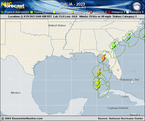
Copy of official data Hurricane Idalia Discussion Number 13 NWS National Hurricane Center Miami FL AL102023 500 PM EDT Tue Aug 29 2023 The first stages of an eye have been taking shape in visible satellite imagery. The hurricane has a relatively small Central Dense Overcast and a prominent band of deep convection extending over the eastern semicircle, reaching across the Florida peninsula southward across western Cuba. An Air Force Reserve Hurricane Hunter aircraft just measured a peak 700-mb flight-level wind of 91 kt with the pressure falling to 972 mb. The initial intensity is therefore set at 85 kt. Idalia is moving faster toward the north, or 360/14 kt, between a mid-level trough over the northwestern Gulf of Mexico and a subtropical ridge over the Greater Antilles. Idalia is expected to continue moving northward and turn north-northeastward as it approaches the Big Bend region of Florida during the next 12-24 hours. There is very little spread among the track guidance, and the NHC official forecast has been placed very close to the HCCA and TVCX consensus aids during the first 24 hours. This has resulted in a westward shift of about 20-25 n mi compared to the previous forecast, although it should be stressed that additional shifts to the track will be possible until the center reaches land. After landfall, Idalia is expected to turn toward the northeast and then east, moving near or along the coast of Georgia and the Carolinas in 36-48 hours. Uncertainty in the track forecast is still quite large after 48 hours, with many of the global models turning Idalia southward, while some of the regional hurricane models still show the storm moving out to sea. As a result, the official track forecast continues to show slow motion on days 4 and 5. The 12-hour intensity forecast shows a 100-kt major hurricane. It is imperative to realize that Idalia is expected to continue strengthening beyond that time, possibly close to the 110 kt shown in the previous forecast, before the center reaches land. Weakening is expected after landfall, but due to the system's expected fast motion, it is possible that Idalia could maintain hurricane intensity as it moves across southern Georgia and approaches the coasts of Georgia and South Carolina. After Idalia's center moves offshore over the western Atlantic, strong shear is likely to limit re-intensification, and the official forecast essentially flatlines the intensity on days 2-5. KEY MESSAGES: 1. Catastrophic impacts from storm surge inundation of 10 to 15 feet above ground level and destructive waves are expected somewhere between Aucilla River and Yankeetown, Florida. Life-threatening storm surge inundation is likely elsewhere along portions of the Florida Gulf Coast where a Storm Surge Warning is in effect. Residents in these areas should follow any advice given by local officials. 2. There is the potential for destructive life-threatening winds where the core of Idalia moves onshore in the Big Bend region of Florida, with hurricane conditions expected elsewhere in portions of the Hurricane Warning area along the Florida Gulf Coast. Strong winds will also spread inland across portions of northern Florida and southern Georgia near the track of the center of Idalia where Hurricane Warnings are in effect. Residents in these areas should be prepared for long-duration power outages. Damaging hurricane-force winds are possible in portions of eastern Georgia and southeastern South Carolina where Hurricane Watches are in effect. 3. Areas of flash, urban, and moderate river flooding, with locally considerable impacts, are expected across the Florida Big Bend, central Georgia and South Carolina, through eastern North Carolina later tonight into Thursday. FORECAST POSITIONS AND MAX WINDS INIT 29/2100Z 26.1N 84.8W 85 KT 100 MPH 12H 30/0600Z 28.3N 84.5W 100 KT 115 MPH 24H 30/1800Z 31.0N 82.9W 75 KT 85 MPH...INLAND 36H 31/0600Z 32.9N 80.2W 50 KT 60 MPH...INLAND 48H 31/1800Z 33.9N 77.1W 45 KT 50 MPH...OVER WATER 60H 01/0600Z 33.8N 74.2W 45 KT 50 MPH 72H 01/1800Z 33.3N 71.8W 45 KT 50 MPH 96H 02/1800Z 32.3N 69.6W 45 KT 50 MPH 120H 03/1800Z 31.7N 69.0W 45 KT 50 MPH $$ Forecaster Berg |