Official Discussion issued by the National Hurricane Center
Idalia (AL102023) DATA RELEASED: 8/29/2023 4:00:00 AM UTC
|
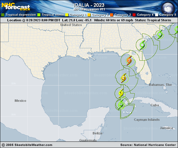
Copy of official data Hurricane Idalia Discussion Number 11 NWS National Hurricane Center Miami FL AL102023 400 AM CDT Tue Aug 29 2023 Radar data from western Cuba indicates that Idalia is becoming better organized. Most of an eyewall has formed, with much more curvature in the banding features and overall radar pattern. Satellite imagery also shows the center of Idalia firmly within the central dense overcast. Thus, the initial wind speed is raised to 65 kt, in accordance with the latest TAFB satellite classification. The hurricane is accelerating northward this morning, now moving at about 9 kt. Idalia should move faster to the north or north-northeast through landfall on Wednesday between mid-level ridging over Florida and a trough dropping into the western Gulf of Mexico. There has been a westward shift in the model guidance overnight, perhaps due to the trough tugging Idalia more northward before taking a north-northeast turn. It should be noted that the ECMWF ensemble shows many of its strongest members on the eastern side of its guidance envelope, which is a reasonable place to be given the synoptic pattern. The new NHC forecast is adjusted a little to the west but is now east of the model consensus on the eastern side of the reliable model guidance. After Idalia leaves the eastern United States coastline, the track forecast becomes highly uncertain and little change was made to the previous forecast. With an inner core now present, the stage is set for Idalia to rapidly intensify before landfall. Shear should continue to lower over the cyclone as an upper-level trough departs the northeastern Gulf of Mexico and ridging builds closer to the cyclone. These changes, combined with extremely warm and deep waters the hurricane will be traversing, all strongly point to rapid intensification. The new forecast is similar to the previous one, and confidence is increasing in an extremely dangerous major hurricane making landfall Wednesday along the west coast or Big Bend region of Florida. KEY MESSAGES: 1. There is a danger of life-threatening storm surge inundation along portions of the Florida Gulf Coast where a Storm Surge Warning is in effect, including Tampa Bay and the Big Bend region of Florida. Inundation of 8 to 12 feet above ground level is expected somewhere between Chassahowitzka and Aucilla River. Residents in these areas should follow any advice given by local officials. 2. Hurricane conditions are expected within portions of the Hurricane Warning area along the Florida Gulf Coast, with the potential for destructive winds where the core of Idalia moves onshore. Strong winds will also spread inland across portions of northern Florida near the track of the center of Idalia. 3. Heavy rainfall is expected across portions of western Cuba and may produce areas of flash and urban flooding as well as landslides. Areas of flash and urban flooding, some of which may be locally significant, are expected across portions of the west coast of Florida, the Florida Panhandle, and southern Georgia beginning today into Wednesday, spreading into portions of the eastern Carolinas Wednesday into Thursday. FORECAST POSITIONS AND MAX WINDS INIT 29/0900Z 23.1N 85.0W 65 KT 75 MPH 12H 29/1800Z 24.9N 84.8W 85 KT 100 MPH 24H 30/0600Z 27.8N 84.3W 105 KT 120 MPH 36H 30/1800Z 30.6N 82.9W 70 KT 80 MPH...INLAND 48H 31/0600Z 32.7N 80.5W 50 KT 60 MPH...INLAND 60H 31/1800Z 33.8N 77.5W 50 KT 60 MPH...OVER WATER 72H 01/0600Z 33.9N 74.4W 50 KT 60 MPH 96H 02/0600Z 33.3N 71.5W 45 KT 50 MPH 120H 03/0600Z 32.5N 70.5W 40 KT 45 MPH $$ Forecaster Blake |