Official Discussion issued by the National Hurricane Center
Franklin (AL082023) DATA RELEASED: 8/22/2023 3:00:00 PM UTC
|
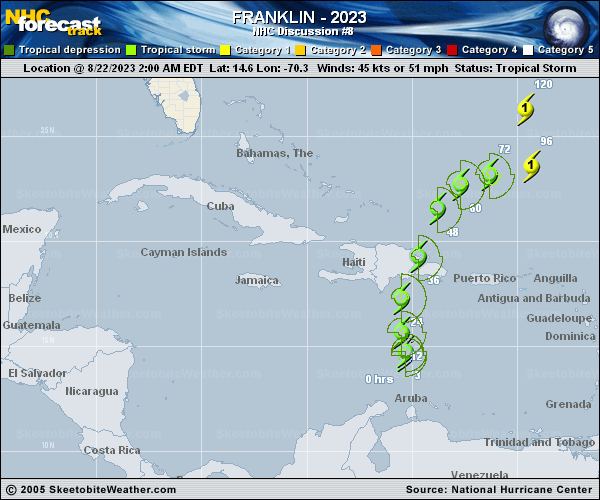
Copy of official data Tropical Storm Franklin Discussion Number 8 NWS National Hurricane Center Miami FL AL082023 1100 AM EDT Tue Aug 22 2023 It is unclear this morning if Franklin still has a well-defined center of circulation. Visible satellite images suggest that broad low-level turning is occurring well to the west of the bulk of Franklin's deep convection, and there is no clear evidence that a center exists near, or that a new center if re-forming beneath, the convection. It appears that scatterometer will miss Franklin and be of no help in assessing the wind field, but a NOAA Hurricane Hunter aircraft is scheduled to investigate the system later this afternoon. For now, the initial intensity is held at 45 kt, which is right in the middle of the various subjective and objective satellite estimates. If Franklin does still have a center, it is assumed to have jumped or re-formed a bit to the west where there is new convection. This position gives the storm an overall motion over the past 12 hours toward the northwest (325 degrees) at 6 kt. Franklin is positioned within the southern extent of a large mid-level trough, which includes a mid-/upper-level low centered south of Bermuda. While the steering flow is weak, this should cause Franklin to move slowly northward and then northeastward for the next 4 days or so. By day 5, a new shortwave trough is likely to develop over New England, with ridging strengthening over the central Atlantic, and Franklin is forecast to turn back toward the north at that time. Largely because of the adjustment in the initial position, all of the track guidance has shifted westward on this cycle. The NHC track forecast has also been moved westward, although it is on the eastern side of the guidance envelope and fairly close to the typically-reliable HCCA consensus aid. That said, there is greater-than-usual uncertainty in Franklin's forecast track given potential re-formations of the center. Moderate-to-strong westerly shear is expected to continue over Franklin for the next 4 days or so. In addition, the system is forecast to move over the rugged terrain of Hispaniola within the next 24-36 hours. As a result, little change in strength is anticipated before Franklin reaches Hispaniola, and some weakening is likely while it is crossing the island. Some intensification is then noted in the 3-5 day period when environmental conditions begin to become a little more conducive for strengthening. The NHC intensity forecast is near the HCCA and IVCN consensus aids for much of the 5-day forecast period. KEY MESSAGES: 1. Heavy rainfall from Franklin is expected across portions of Puerto Rico and Hispaniola into Thursday. The heavy rainfall may produce areas of flash and urban flooding as well as river rises and mudslides. Across Hispaniola, significant and potentially life-threatening flash flooding is possible Tuesday into Wednesday. 2. Franklin is expected to bring tropical storm conditions to portions of the Dominican Republic and Haiti, where Tropical Storm Warnings are in effect, beginning later today and continuing through Wednesday. FORECAST POSITIONS AND MAX WINDS INIT 22/1500Z 15.5N 71.1W 45 KT 50 MPH 12H 23/0000Z 16.5N 71.3W 50 KT 60 MPH 24H 23/1200Z 18.3N 70.9W 45 KT 50 MPH...S COAST OF DOM REPUB 36H 24/0000Z 20.4N 70.2W 40 KT 45 MPH...OVER WATER 48H 24/1200Z 22.1N 69.3W 40 KT 45 MPH 60H 25/0000Z 22.9N 68.2W 45 KT 50 MPH 72H 25/1200Z 23.3N 67.1W 50 KT 60 MPH 96H 26/1200Z 24.2N 66.3W 60 KT 70 MPH 120H 27/1200Z 27.1N 67.1W 70 KT 80 MPH $$ Forecaster Berg |