Official Discussion issued by the National Hurricane Center
Franklin (AL082023) DATA RELEASED: 9/1/2023 9:00:00 AM UTC
|
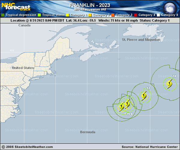
Copy of official data Hurricane Franklin Discussion Number 47 NWS National Hurricane Center Miami FL AL082023 500 AM AST Fri Sep 01 2023 Franklin has a much more asymmetric appearance this morning, indicative of the increasingly disruptive upper-wind pattern associated with an approaching mid-latitude baroclinic zone. In fact, the remaining deep convective mass is about 100 mi southeast of the surface center. The initial intensity is lowered to 70 kt and is based on a compromise of the available subjective and objective intensity estimate techniques. Franklin is showing signs of losing its tropical characteristics while drier, more stable mid-level air and increasing northwesterly shear impedes over the northwest portion of the cyclone. Consequently, the completion of an extratropical transition is expected later tonight or early Saturday. However, little change in strength is forecast, and Franklin should maintain its hurricane-force sustained winds through the weekend. By early next week, gradual weakening is expected, which agrees with a blend of the intensity consensus guidance and the statistical-dynamic SHIPS models. Franklin's initial motion is estimated to be east-northeastward or 060/16 kt. An increase in forward speed toward the northeast is forecast. At the same time, Franklin moves within the mid-latitude steering flow between high pressure to the east, over the central Atlantic, and an extensive baroclinic system moving out of the Canadian Maritimes. Global model spread continues to increase beyond day 3. Two scenarios are possible. The European models take a southeastward track while interacting with a larger cut-off low meandering west of the Iberian peninsula. The other solution involves the GFS and the regional guidance which gradually turns the cyclone northeastward to northward over the northeast Atlantic. The official forecast track indicates a blend of the two model clusters, lying between both, and is close to the multi-model consensus aid. FORECAST POSITIONS AND MAX WINDS INIT 01/0900Z 37.8N 57.0W 70 KT 80 MPH 12H 01/1800Z 39.1N 54.3W 70 KT 80 MPH 24H 02/0600Z 41.2N 49.8W 70 KT 80 MPH...POST-TROP/EXTRATROP 36H 02/1800Z 43.5N 45.5W 65 KT 75 MPH...POST-TROP/EXTRATROP 48H 03/0600Z 45.7N 41.1W 60 KT 70 MPH...POST-TROP/EXTRATROP 60H 03/1800Z 47.2N 36.6W 50 KT 60 MPH...POST-TROP/EXTRATROP 72H 04/0600Z 48.4N 32.8W 40 KT 45 MPH...POST-TROP/EXTRATROP 96H 05/0600Z 50.3N 27.9W 35 KT 40 MPH...POST-TROP/EXTRATROP 120H 06/0600Z 51.6N 25.0W 30 KT 35 MPH...POST-TROP/EXTRATROP $$ Forecaster Roberts |